Sentinel, Roosevelt & Taft Loop - An Awesome Yosemite Hike

Scrambling up Sentinel Dome
This week Yosemite National Park celebrates its 130th birthday, and I’m so excited to take you with me on one of my absolute favorite hikes in all of Yosemite today. We will visit three incredible scenic view points…two of which are popular Yosemite favorites, and one magnificent overlook you may not have even heard of before. So let’s head out on the Sentinel Dome, Roosevelt Point, and Taft Point trail loop.
Trail leading towards Sentinel Dome

View of El Capitan from Sentinel Dome
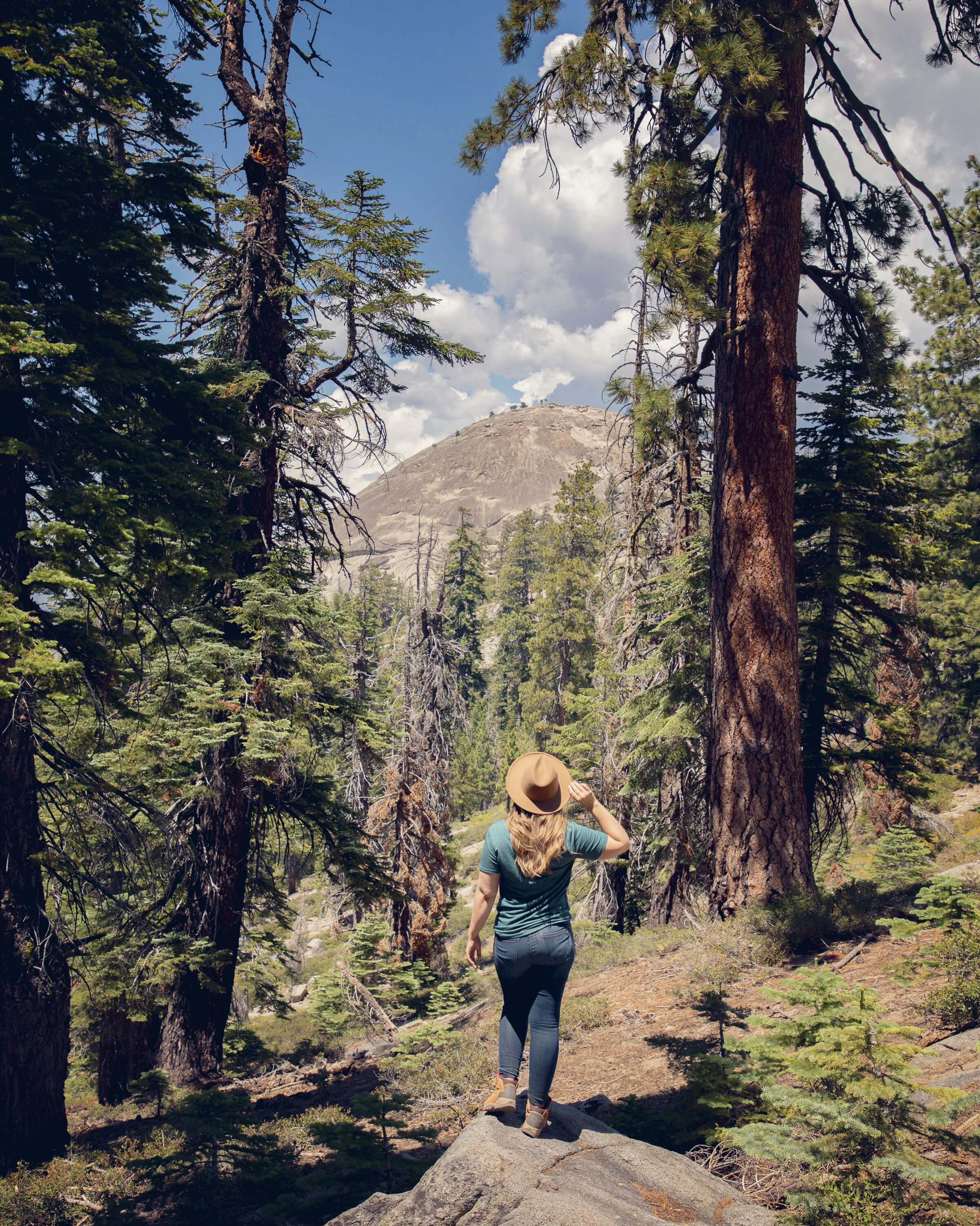
Sentinel Dome
We’re starting off from the trailhead to Sentinel Dome. This hike starts in the shade, but quickly opens up to stunning views of the dome as we traverse the rolling gravel and smooth white granite. This beginning section of our hike is just over a mile with nearly 500 feet in elevation gain. See this post for all the details about visiting Sentinel Dome. Once we’re done enjoying the views of Yosemite Falls, Half Dome, and El Capitan from here, we’re heading down the dome and continuing our journey by making a left, following the signs towards Taft Point instead of heading right back towards the trailhead.

View of Half Dome from Sentinel Dome

View of Yosemite Falls from Roosevelt Trail (during late Summer)
Roosevelt Trail
Once we’ve enjoyed Sentinel Dome, we’ll begin hiking along the Pohono Trail. In 1/4 mile we’ll pass the weather station, which is a perfect guide point showing us we’re heading in the right direction. Just over a mile into the section of the hike, we veer right on the lower path leaving the Pohono Trail and hugging the cliff edge, hiking the incredibly picturesque Roosevelt Trail for half a mile. This trail is an amazing spot to visit in the Spring to enjoy unobstructed views of Yosemite Falls, and any time of year the views of El Capitan are unparalleled here.

Cliff edge along Pohono Trail. Just past this feature is where Roosevelt Trail veers to the right.

View of El Capitan from Roosevelt Trail
Roosevelt Point
There are multiple spots to stop and take in the breathtaking views of the panoramic rim along this trail. After gaining over 400 feet in elevation, we reach the “high point” here, Roosevelt Point. One thing that makes this spot so special is that unlike Sentinel Dome and Taft Point, this area never gets crowded. In fact, I recently spent Labor Day weekend hiking this trail, and on Saturday from 11am until 1pm, I only saw three other people at this spot (I had the views to myself most of the time). This part of the hike does take some extra energy and time, but that’s a part of what makes Yosemite so magical – if you’re willing to put in just a little extra effort (in this case 3 miles and 1000 feet of elevation gain), you can escape the crowds and enjoy your very own private symphony of Yosemite’s wild beauty.

Walking towards the edge of Roosevelt Point

Sitting on the edge of Roosevelt Point with El Capitan in the distance.
Taft Point Trail
As we leave Roosevelt Point we are officially halfway through our journey. The hike to Taft Point is as technically challenging as this adventure will get. We have 500 feet of elevation change in under 1.5 miles as we climb over multiple fallen trees and cross a couple creeks (in the Fall months you can often just hop over the trickling water, but in the Spring when the water is raging with the snowmelt, you should be prepared to get your feet wet). This is the most shaded section of our journey…we hike surrounded by moss covered pine trees until we reach the last vista views of our hike at Taft Point.

Cliff edge at Taft Point

The actual “Taft Point” cliff edge
Taft Point
It’s unlikely that we will ever get this popular spot completely to ourselves…it’s a much-loved sunrise and sunset photography area with an easy 2.2 mile round trip hike on its own. Taft Point is known for its sheer cliff top edges and massive drop offs, but there is one famous lookout point with railing for those with a fear of heights. The giant fissures (huge cracks in the granite…some over 100 feet) are also a must see before taking the 1 mile hike back to the trailhead where we started out on journey.

The actual “Taft Point” cliff edge

Fissures at Taft Point
Know Before You Go
• Please be considerate of the Leave no Trace Principles to help keep this place wild and beautiful.
• This loop can be hiked in either direction. I think it is both physically easier and more visually appealing to start at Sentinel Dome and end at Taft Point, but you can certainly reverse this hike.
• The full loop takes just over 5 miles, but I often clock at least 7 miles with all the possible exploring there is at each location.
• Always plan ahead and check the weather. I have encountered both unforeseen rogue thunderstorms and sudden smoke from distant wildfires at different times while hiking this trail.
• This hike requires climbing over fallen trees, scrambling up granite boulders, and crossing streams, so plan proper footwear accordingly.
• Always bring twice as much water as you think you might need, snacks and sun protection, as well as a first aid/survival kit.
• Glacier Point Road will be closed for road repairs in 2021, so these viewpoints will only be accessible by strenuous trails, including the Four Mile, Pohono & Panorama Trails. Update as of 12/20 the road rehabilitation project has been pushed back to 2022 due to Covid.
Other Yosemite Points of Interest
• Taft Point & Sentinel Dome
(same trailhead)
• Glacier Point
( 1 mile N)
• Yosemite Valley
(30 miles)
• Cooks Meadow/Lower Falls Loop
(29 miles)
• Pioneer Yosemite History Center
(27 miles)
• Wawona Swinging Bridge
(31 miles)
• Tioga Pass
(38 miles)
• Mammoth
(120 miles)
• Sequoia/Kings Canyon NP
(170 miles)

Cliff edge at Taft Point
In Summary & Behind the Blog Video
Thanks for joining me today on this wonderful Yosemite hike. For more information see my Behind the Blog video below…and until next week I hope you find adventure and encouragement wherever you go.
View these quick video guides below:
If you enjoyed this post, you might also like…


Some of the links on this website are affiliate links. If you make a purchase through these links, we may earn a small commission at no extra cost to you. This helps in offsetting the cost of running this site so we can continue to provide you with free content to help you plan your next adventure.