Sierra Vista Scenic Byway: Day Trip Adventure Near Yosemite

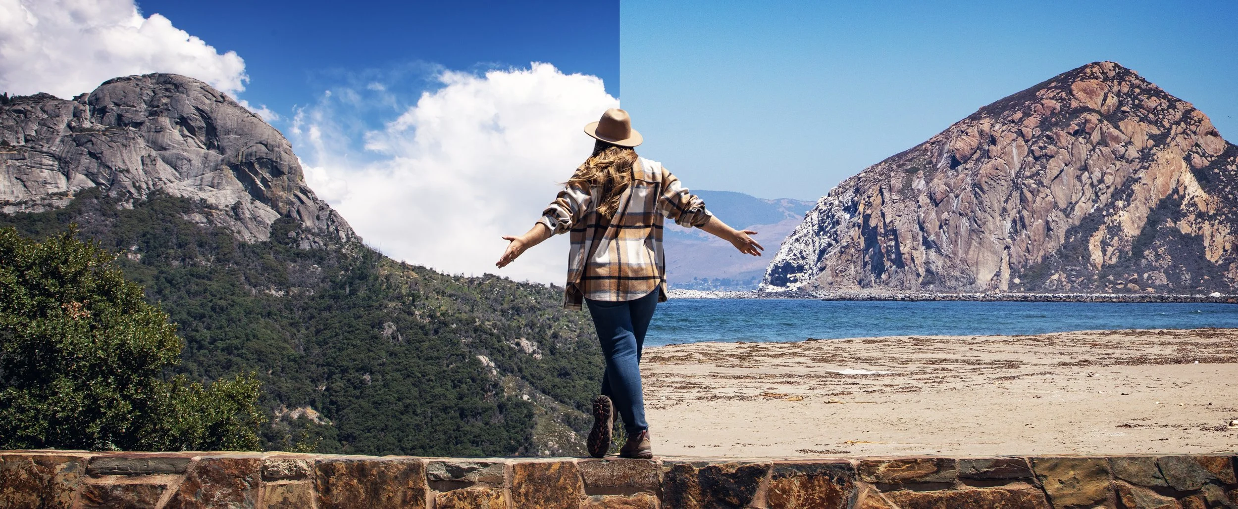
Hi friends! When you think of road trips in or around Yosemite National Park, most people picture Tioga Pass or Glacier Point Road. But tucked away in the Sierra National Forest is one of California’s most underrated scenic drives — the Sierra Vista Scenic Byway. This backcountry route winds through granite peaks, lush meadows, dense pine forests, rugged overlooks, and fascinating historic stops that bring the Sierra Nevada’s beauty to life. During my recent partnership with Visit Yosemite | Madera County, I had the chance to explore this incredible drive firsthand, and it truly felt like uncovering a hidden gem. Whether you’re chasing views, history, or just a peaceful drive through the forest, the Sierra Vista Scenic Byway belongs on your Yosemite road trip itinerary.

Exploring the Sierra Vista Scenic Byway near Yosemite National Park
Yosemite 2-4 Day Summer Itinerary & Travel Guide
If you’re planning a Yosemite road trip during the summer months, make sure to download my complete Yosemite 2-4 Day Summer Itinerary & Travel Guide, which includes an hour-by-hour schedule, Google & Apple map pin locations, the best stargazing spots, a dining guide, recommendations on where to stay, activities outside the park, and more! Download it today and make your Yosemite planning easy!


Views from Mile High Vista along the Sierra Vista Scenic Byway
Location & Overview
The Sierra Vista Scenic Byway stretches for about 100 miles through the Sierra National Forest, just outside of Yosemite’s southern entrance near Oakhurst and Bass Lake. It’s a seasonal scenic drive that usually fully opens in late spring or early summer, once snow has melted at higher elevations. Along the way, you’ll pass through towering pine forests, sweeping mountain vistas, unique granite rock formations, and historic sites that tell the story of California’s Sierra Nevada. Because it’s a loop, you can start from different points, but most visitors begin in the town of North Fork, known for being the geographical center of California. Plan to set aside a full day for this drive — not because of traffic, but because you’ll want to stop at every single viewpoint, meadow, and landmark along the way.

Globe Rock along the Sierra Vista Scenic Byway

Norris Creek Bridge detour along the Sierra Vista Scenic Byway
Road Conditions
It’s important to note that the majority of the drive is paved and passable by most vehicles, providing access to the many of the Byway’s highlights for travelers with standard sedans. However, there are a couple sections of the drive that are currently unpaved, rough, and should only be attempted with a high clearance vehicle equipped with AWD or 4WD. One section is the 6S10 road in between Cold Springs Summit and Nelder Grove. This road is rough in sections, but can handle most sedans if taken slowly and carefully. The road extending off this stretch of the byway that takes you to the Fresno Dome Trailhead is very rough, and should only be attempted with high clearance vehicles.
The other section of the Byway that requires something more than a standard sedan is the detour around the Norris Creek Bridge, which is currently undergoing reconstruction. The detour is narrow, bumpy, and high clearance with AWD or 4WD is highly recommended. Come prepared with physical maps and/or pre-downloaded maps of the area that can be accessed without cell service. I personally love using Gaia GPS for iPhone and Android devices.

Jesse Ross Cabin on the Sierra Vista Scenic Byway
Highlights & Stops
The Sierra Vista Scenic Byway has countless stops, both marked and unmarked, that are worthy of exploration. Below I’ve put together some of my personal favorites to help you plan your own Sierra Nevada adventure.

North Fork Sign & official start to the Sierra Vista Scenic Byway
North Fork
Our journey kicks off in the charming town of North Fork, California, where a wooden sign adorned with American flags celebrates the geographical center of the state and marks the official start to the Sierra Vista Scenic Byway. This little mountain town has a cozy, welcoming vibe, perfect for grabbing a delicious latte at Rebelz Coffee before hitting the byway. Other notable spots to check out in town are The Gnarly Carrot and the Sierra Mono Museum.

Exact Geographical Center of California
Geographical Center of California
Just outside North Fork, you can actually visit the marker that designates the exact geographical center of California. It’s a fun photo opportunity and a unique way to say you’ve stood in the “heart” of the Golden State—literally!

Redinger Overlook along the Sierra Vista Scenic Byway
Redinger Overlook
This scenic pullout gives you a sweeping view of Redinger Lake along the San Joaquin River, tucked into the canyon far below. The shimmering water framed by the towering Sierra Nevada hills makes this stop worth lingering at with a camera in hand. A shaded bench also makes this a great spot to relax and enjoy a picnic before continuing on.

Jesse Ross Cabin on the Sierra Vista Scenic Byway
Jesse Ross Cabin
Step back in time at the historic Jesse Ross Cabin, a preserved homestead that offers a glimpse into what pioneer life was like in the Sierra during the late 1800s. Located just a short walk from the main highway, this is now the oldest known residence still standing in Madera County.

Views of Mammoth Pool from Mile High Vista
Mile High Vista
This is one of the most dramatic viewpoints along the byway. From Mile High Vista, you’ll be treated to a jaw-dropping panorama of the San Joaquin River canyon, Mammoth Pool Reservoir, peaks of the Sierra crest in the distance, as well as the nearby Eagle Beaks, a truly unique mountain peak that resembles several raptor profiles.

Arch Rock along the Sierra Vista Scenic Byway
Arch Rock
A short path leads down to a natural granite arch tucked away in a dense red fir forest. The Arch Rock is one of very few formations like this in the Sierra Nevada, and it’s a remarkable example of how flowing water has shaped this terrain over thousands of years.

Jackass Meadow along Sierra Vista Scenic Byway
Jackass Meadow
Despite its funny name, Jackass Meadow is pure Sierra beauty. In the summer, wildflowers blanket the open meadow framed by towering lodgepole pine, making this an ideal location to spot wildlife.

Views from Portuguese Overlook
Portuguese Overlook
This overlook right off the side of the road delivers another gorgeous view of the surrounding Sierra Nevada foothills, with layered ridges stretching endlessly into the horizon. It makes for a quick stop, but totally worth it.

Globe Rock on the Sierra Vista Scenic Byway near Yosemite
Globe Rock
One of the most unique stops along the Sierra Vista Scenic Byway, Globe Rock is a massive round granite boulder balanced on a rocky outcrop. It looks like it could roll off at any moment, but it’s been perched here for centuries. Rumor has it that Theodore Roosevelt has his picture taken at this geological oddity, and It was once a place of deep significance for the Mono Indians. In fact, you can still see several mortars in the rock bed surrounding the formation.

Pie & ice cream at Jones Store in Beasore Meadows
Jones Store
This drive isn’t complete without a rustic stop for food at the Jones Store. This seasonal, off-the-grid spot has a history going back nearly a century. The Jones Store serves up cold drinks, mouthwatering burgers and homemade pie. No electricity, no frills — just great food and beautiful nature views.

Cold Springs Meadow along the Sierra Vista Scenic Byway
Cold Springs Summit
As you climb higher into the Sierra, Cold Springs Summit provides sweeping views and a refreshing coolness compared to the lower elevations. It’s a perfect place to stretch your legs. Situated at 7300 feet, summer wildflowers blanket Cold Springs Meadow surrounded by towering pines.

Fresno Dome Vista along the Sierra Vista Scenic Byway
Fresno Dome Vista
Pull over at the Fresno Dome Vista for a look at Fresno Dome’s massive granite top rising out above the forest treeline. It offers a unique view looking up at the summit of the Fresno Dome hike from below, a great preview if you decide to take the nearby trail to the top.

Sunset atop Fresno Dome near Yosemite
Fresno Dome Hike
If you’re up for a short but rewarding hike, the Fresno Dome Trail takes you right to the summit. The views from the top stretch across the Sierra Nevada and are absolutely worth the effort. See my full Fresno Dome blog post here.

Standing beneath a giant sequoia tree
Nelder Grove (Reopening in Fall 2025)
One of the most anticipated stops, Nelder Grove is home to over 65 mature giant sequoias. It has been closed due to wildfire recovery, but is expected to reopen in Fall 2025. Once it does, it will once again be one of the best places outside of Yosemite to walk among these ancient giants.

Redinger Overlook along the Sierra Vista Scenic Byway
Frequently Asked Questions
How many miles is the Sierra Vista Scenic Byway?
The full loop is just shy of 100 miles.
How many hours will it take to drive the full Sierra Vista Scenic Byway?
Plan on 5–7 hours depending on how often you stop.
Do I need a 4WD and/or high clearance vehicle to drive the Sierra Vista Scenic Byway?
Most of the byway is paved and accessible by standard vehicles, though a couple of sections are unpaved and rough. There is a detour around the Norris Creek Bridge (currently under reconstruction), and the section of road between Cold Springs Summit and Nelder Grove is unpaved and quite bumpy in spots. High clearance with AWD or 4WD is highly recommended for these areas.
Is the Sierra Vista Scenic Byway really curvy?
Yes, it winds through mountain terrain, but the road is manageable if you take your time.
When will Nelder Grove open back up?
It’s projected to reopen in Fall 2025 after wildfire recovery.
How difficult is the hike to the top of Fresno Dome?
It’s an easy-to-moderate 1.75-mile round trip hike with 250 feet in elevation, but the views are well worth it. The more challenging aspect of this adventure is the drive to the trailhead. The road is very rough with several deep ruts along the way, requiring a high clearance vehicle with AWD or 4WD.
When is the Jones Store open?
Usually late spring through early fall, depending on snow conditions. Their hours change occasionally, but as of the writing of this post, they’re open Wed-Sun from 10am-4pm (or until they run out of food).
Do I have to drive the full Sierra Vista Scenic Byway?
No, you can pick and choose sections if you’re short on time or if you don’t have a high clearance vehicle that can handle the Norris Creek Bridge detour.
Where is the best place to start the Sierra Vista Scenic Byway?
Most travelers begin in North Fork, CA, driving the loop in a counter-clockwise direction. You can, however, drive the loop in reverse, starting at the far north end of Oakhurst or in Bass Lake.
Are there bathrooms along the Sierra Vista Scenic Byway?
Yes, but they are limited — plan ahead.
Are there restaurants along the Sierra Vista Scenic Byway?
Jones Store is the main option along the route, and their hours of operation are limited. Plan to bring snacks and plenty of water.
What towns are near the Sierra Vista Scenic Byway?
North Fork, Oakhurst, and Bass Lake are nearby.
Can I drive the Sierra Vista Scenic Byway year round?
No, it’s usually open late spring through mid fall, depending on snow.
Is Globe Rock difficult to find?
No, it’s located right off the byway, although there isn’t clearly marked signage, so you might drive right past it if you aren’t paying attention.
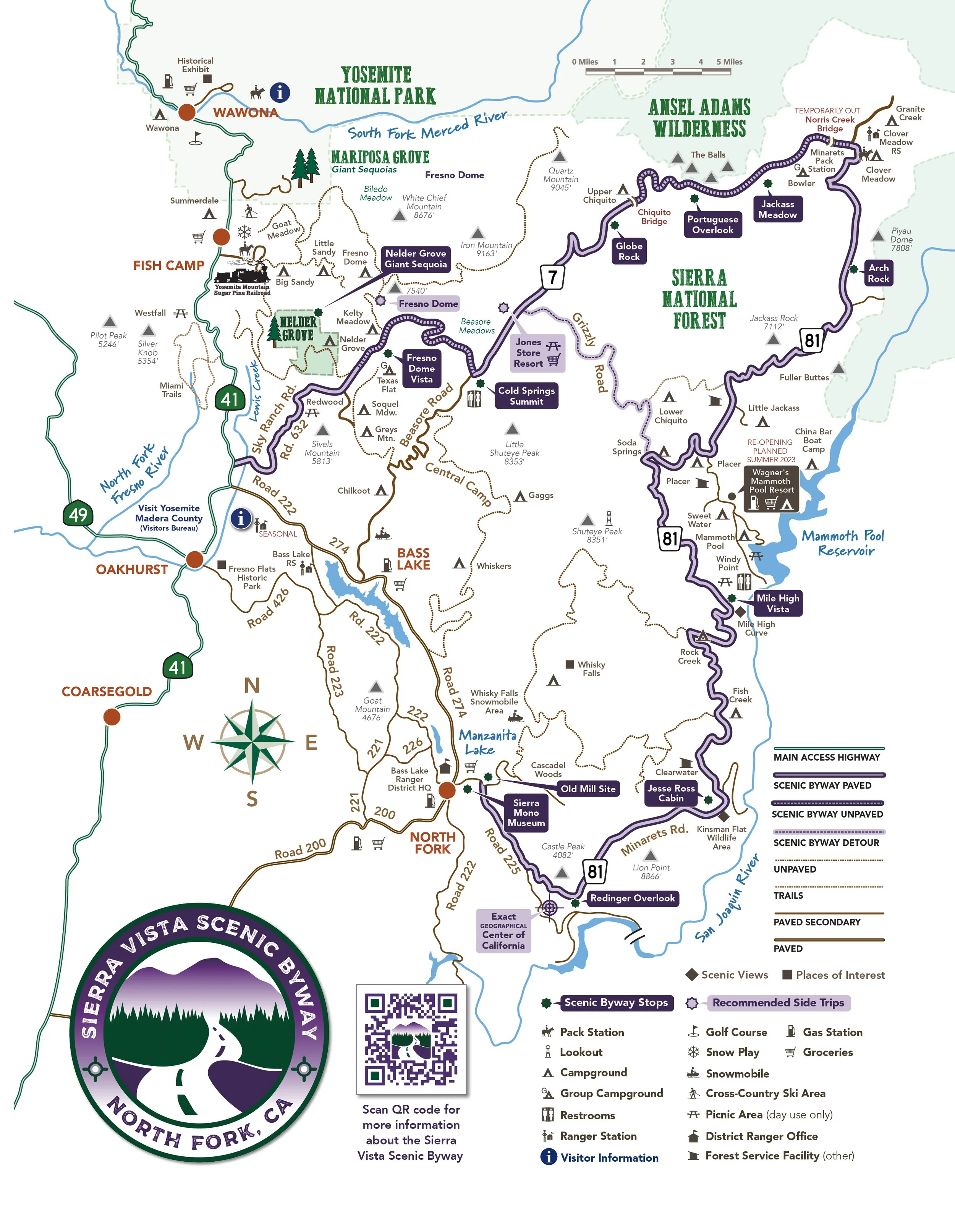
Sierra Vista Scenic Byway official map with key highlights

Sierra Vista Scenic Byway map showing Norris Creek Bridge detour area
Know Before You Go
• The Sierra Vista Scenic Byway is typically open from late Spring through mid Fall, depending on snow.
• Much of the region along the byway was hit by the 2020 Creek Fire. The burn scars are still visible along the eastern side of the loop, but there is wonderful evidence of life returning to the area...and the views are still incredible.
• The Norris Creek Bridge is undergoing a reconstruction project from the 2020 Creek Fire. A detour is provided, but the road is rough and requires a high clearance vehicle. See the map pictured above.
• Make sure to fill up your gas tank prior to driving the Sierra Vista Scenic Byway. There are no gas stations along the drive.
• There are spots with restrooms occasionally, but they are few and far between, so take advantage of them when possible.
• Food and drinks can only be found at Jones Store in Beasore Meadows, which has limited hours of operations. Plan on bringing all your food and water for the day.
• Cell service is unreliable in much of Yosemite National Park and Sierra National Forest, so bring a reliable GPS device with pre-downloaded maps. Gaia GPS for iPhone and Android devices is a great option that I use on all my mountain road trips.
• This is black bear country. Bears and other wildlife can be present on trails and roadways at any time of the day or night. Feeding and approaching wildlife is dangerous and illegal. Make sure to properly store your food.
• If you’re not familiar with the Leave No Trace Principles, consider familiarizing yourself with them before your trip. Please help leave this special place better than you found it so its natural beauty can be enjoyed for years to come.

Cheeseburger lunch at the Jones Store in Beasore Meadows
Visit Yosemite | Madera County
I’d like to give a special thank you to Visit Yosemite | Madera County, an invaluable resource for anyone planning a trip to Yosemite National Park and the surrounding regions. Stop at the Oakhurst Visitor Center for expert advice, access to maps, and insider tips. Here you’ll discover the many hidden gems of Madera County, and make sure to download your free visitor guide at YosemiteThisYear.com for answers to all your questions about visiting California's Southern Gateway to Yosemite.

Exploring the Jesse Ross Cabin along the Sierra Vista Scenic Byway
In Summary
Thanks so much for joining me this week just south of Yosemite National Park. For a virtual visit of the Sierra Vista Scenic Byway, make sure to watch my Behind the Blog video located at the top of this post, or watch it on YouTube here. Until next week, I hope you find adventure and encouragement wherever you go.

Eagle Beak formation seen near Mile High Vista
Downloadable Itineraries & Travel Guides

If you enjoyed this post, you might also like…


About Me
I’m Dawn Marie, a travel and lifestyle blogger based out of Southern California. With in-depth articles, travel guides, and reviews on hotels & products, I seek to share my journeys to help you plan for your own. My adventures take me all over California, the western United States, and around the globe...and every Monday I post new content here, including a comprehensive blog post and YouTube video.
Search the Blog
Featured Posts


Etsy Shop
