Taft Point - Epic Clifftop Views in Yosemite National Park

The Summer season in Yosemite National Park is an exciting and beautiful time to visit, particularly because it marks the opening of Glacier Point Road, which provides access to some of the most spectacular views found in all of California. Today I’m thrilled to partner with Visit Yosemite | Madera County as we head out on an unforgettable adventure to Taft Point. Join me along the trail to epic clifftop overlooks, massive granite fissures, and breathtaking scenery of the Yosemite Valley below.

Clifftop overlook at Taft Point in Yosemite
Location
Taft Point soars 3,500 ft above the Yosemite Valley below and offers incredible panoramic views of iconic Yosemite features, such as El Capitan, Cathedral Rocks, and Yosemite Falls. Although you can enjoy these views along the 13-mile (one way) Pohono Trail, the quickest access to Taft Point is from the Taft Point/Sentinel Dome Trailhead along Glacier Point Road about 2 miles before the road ends at the Glacier Point Trailhead. The parking area here has been renovated in recent years, opening up more available parking for this popular Yosemite spot.
FAST FACTS
• Distance: 2.2 miles RT
• Elevation Change: 200 ft
• Difficulty: Easy
Official Taft Point overlook in Yosemite National Park

Official Taft Point with views of El Capitan and Yosemite Valley
History
This spot is named after our 27th President, William Howard Taft. According to newspaper accounts, he and John Muir lunched at this point as they made their way from Glacier Point down to the Valley below over a 3-day trip in October 1909. While the path is now well marked, you can still feel the fierce wildness of nature when exploring this area…and I’m pretty sure my first visit was filled with as much joy and excitement as President Taft’s.

Hiking to Taft Point near Sentinel Creek in Yosemite

Deer along the trail to Taft Point
The Hike
If you read my Sentinel Dome post, then you know the trailhead for both Taft Point and Sentinel Dome are located off the same parking area 13 miles up Glacier Point Road. The trail is situated over 7,500 ft above sea level. As you start down the first path, heading left will take you westward to Taft Point, and a right would lead to Sentinel Dome. The trail to Taft Point leads you downhill through rows of tall trees and serine wooded areas, connecting with the Pohono Trail and eventually opening up atop a large granite shelf. The 2.2-mile round trip adventure is considered an easy hike (can be moderate depending on your comfort level at high altitudes) with a total of 200 ft in elevation change. Depending on recent weather, you will have to look for stable rocks to cross the water filled Sentinel Creek. Keep your eyes peeled for wildlife, especially around dawn and dusk. I’ve been treated to some wonderful moments with nature here...just make sure to maintain a safe distance from any wildlife you encounter along your journey.

Clifftop granite ledge at Taft Point in Yosemite National Park

Granite “balcony” towers above Yosemite Valley and El Capitan
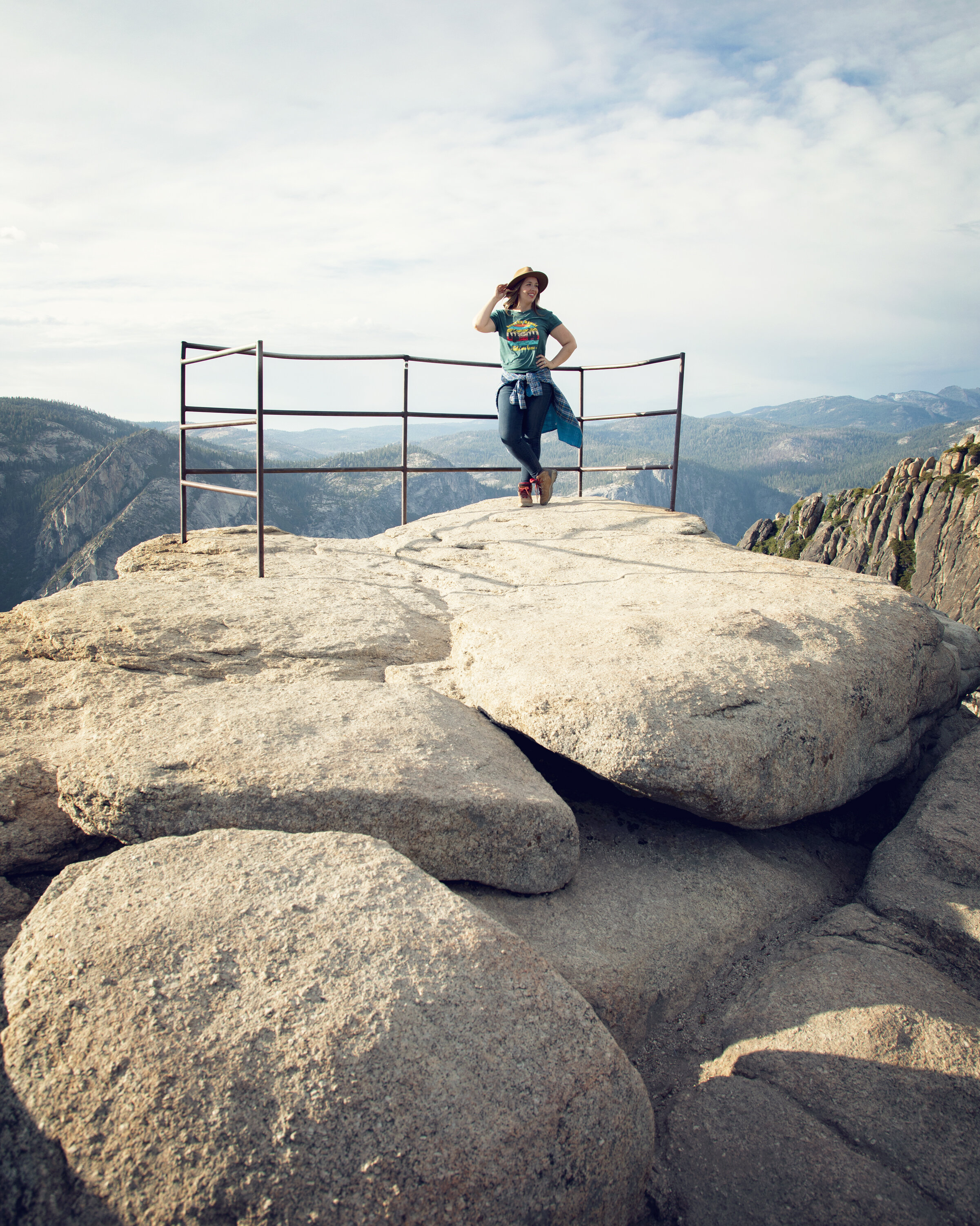
Taft Point Overlooks & Fissures
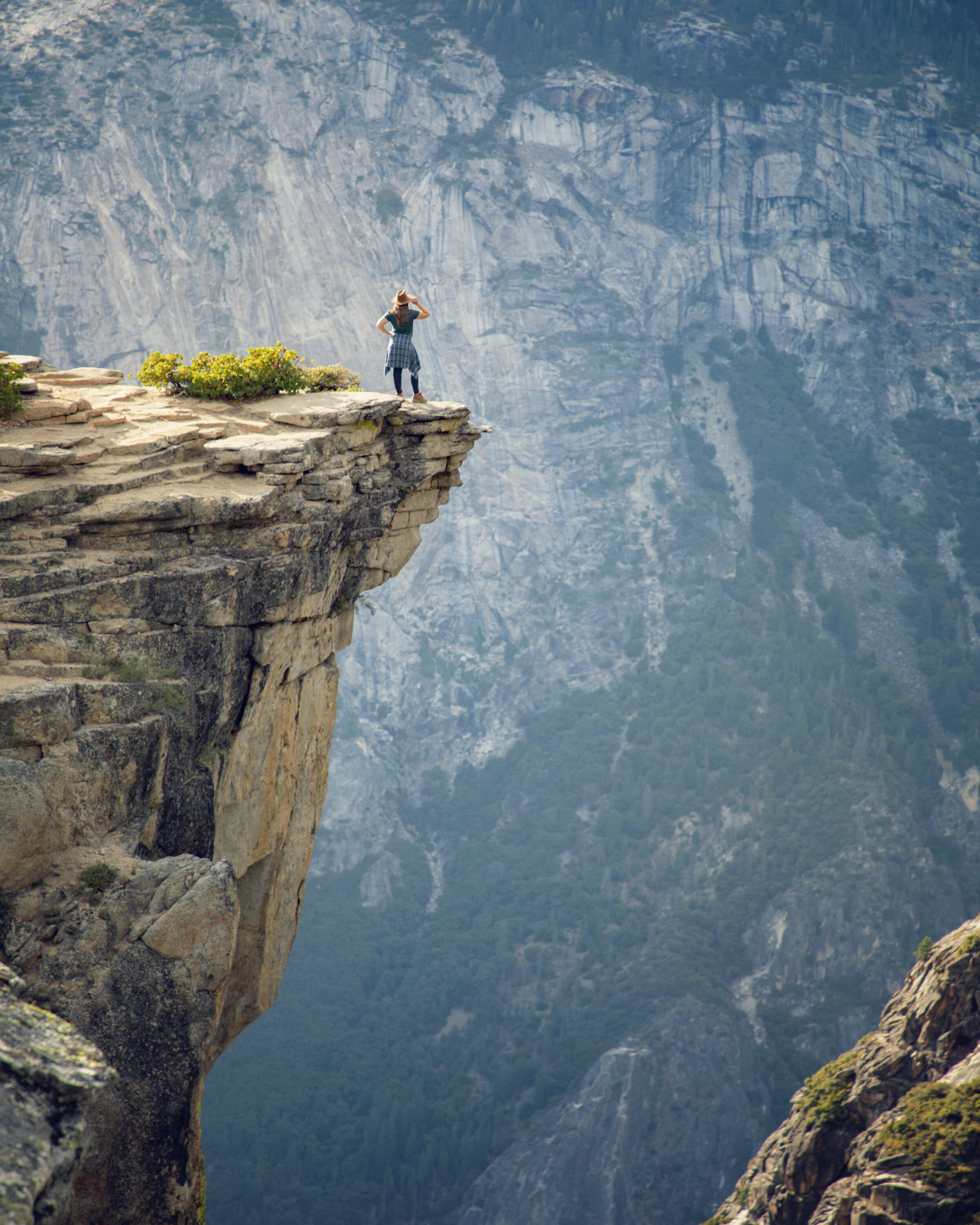
As the forest breaks open, Taft Point and its many viewpoints are revealed in all their glory. There are multiple clifftop lookout ledges to venture out on here, but as you’re heading out towards them, watch your step! There are massive fissures cutting through the granite here, some with massive drop-offs and extending as long as 100 feet.
As you reach the cliff’s edge, you’ll find a small section of railing that has been welded into the rock at of one of the viewpoints (which is the official “Taft Point”), but other than that you are free to roam 3,500 feet above the valley below. One of the most pictured clifftop overlooks is found just beyond the official namesake view, where you can step out onto a stone balcony perched in the heavens, high above the granite cathedral that is Yosemite National Park. From here, it’s incredible to literally look down on El Capitan and Yosemite Falls from above, as well as the meandering Merced River weaving across the valley floor.
Disclaimer: Please be wise as you explore these beautiful views and formations. People have sadly fallen off of these wide open ledges and lost their lives. As you hike around Taft Point and the surrounding areas, you should be careful and you do so at your own risk.

Granite fissures at Taft Point in Yosemite National Park

Yosemite’s Taft Point clifftop views at sunset
Know Before You Go
• The Travel Alerts page on YosemiteThisYear.com is a great resource to reference prior to any Yosemite trip. There you’ll find up-to-date park information, road conditions, and links to everything you might need while preparing for your trip.
• Please be considerate of the Leave no Trace Principles to help keep this place wild and beautiful.
• Glacier Point Road closes for Winter, but skilled cross country skiers can still enjoy the area in the Winter months.
• Although it’ll be a bit more crowded, sunset is absolutely spectacular at Taft Point. Stargazing at night here is also magical...just be sure to bring a headlamp for hiking in the dark.
• While you enjoy the views, be wise and extra cautious as you explore. People have sadly fallen off of these clifftop ledges...please be careful.
• Bathrooms and food storage are available at the trailhead.
• Always bring twice as much water as you think you might need. This is a relatively short hike, but if you’re not used to higher elevations, you can still break a sweat here (I’d plan at least 1-2 hours to really enjoy this hike).
• Wildlife is abundant in Yosemite. Never leave food unattended, especially in your vehicle, as this is black bear territory.
• Always check the official NPS website for the most up-to-date road conditions, air quality, and possible closures prior to your visit.
Top 10 Yosemite Viewpoints

Cathedral Rocks seen from Taft Point at sunset

Official Taft Point viewpoint in Yosemite National Park
In Summary & Post Sponsor
Thanks so much for joining me today in Yosemite National Park. For a virtual visit of my hike to Taft Point, see my Behind the Blog video at the top of this post, or watch it on YouTube here.
I’d like to give a special thank you to the sponsor of this post, Visit Yosemite | Madera County. Please consider stopping off to support the small businesses and local economies of the gateway communities surrounding the park. For great information on what to do inside Yosemite National Park and in Madera County directly to the south (along Highway 41), check out YosemiteThisYear.com and @yosemitemadera on Instagram. Until next time, I hope you find adventure and encouragement wherever you go.
Taft Point views from clifftop ledge
If you enjoyed this post, you might also like…


About Me
I’m Dawn Marie, a travel and lifestyle blogger based out of Southern California. With in-depth articles, travel guides, and reviews on hotels & products, I seek to share my journeys to help you plan for your own. My adventures take me all over California, the western United States, and around the globe...and every Monday I post new content here, including a comprehensive blog post and YouTube video.
Search the Blog
Featured Posts


Etsy Shop
Planning a trip to Yosemite, Sequoia, or Kings Canyon in 2026? This guide breaks down how the new National Park entrance fees and nonresident surcharges impact your visit, plus what U.S. travelers need to know about annual passes, digital passes, fee-free days, and park access. Learn how these updates affect gateway communities like Oakhurst and Visalia and how to support them during your trip.