Sonora Pass High Sierra Adventure - Fall Colors & Favorite Stops

Hi friends and happy Monday! This week we’re continuing our Fall foliage adventures in the Sierra Nevada Mountains. Join me as we take a drive along State Route 108 up and across the Sonora Pass, stopping off to enjoy the Fall colors and some of my favorite spots on this scenic road trip.

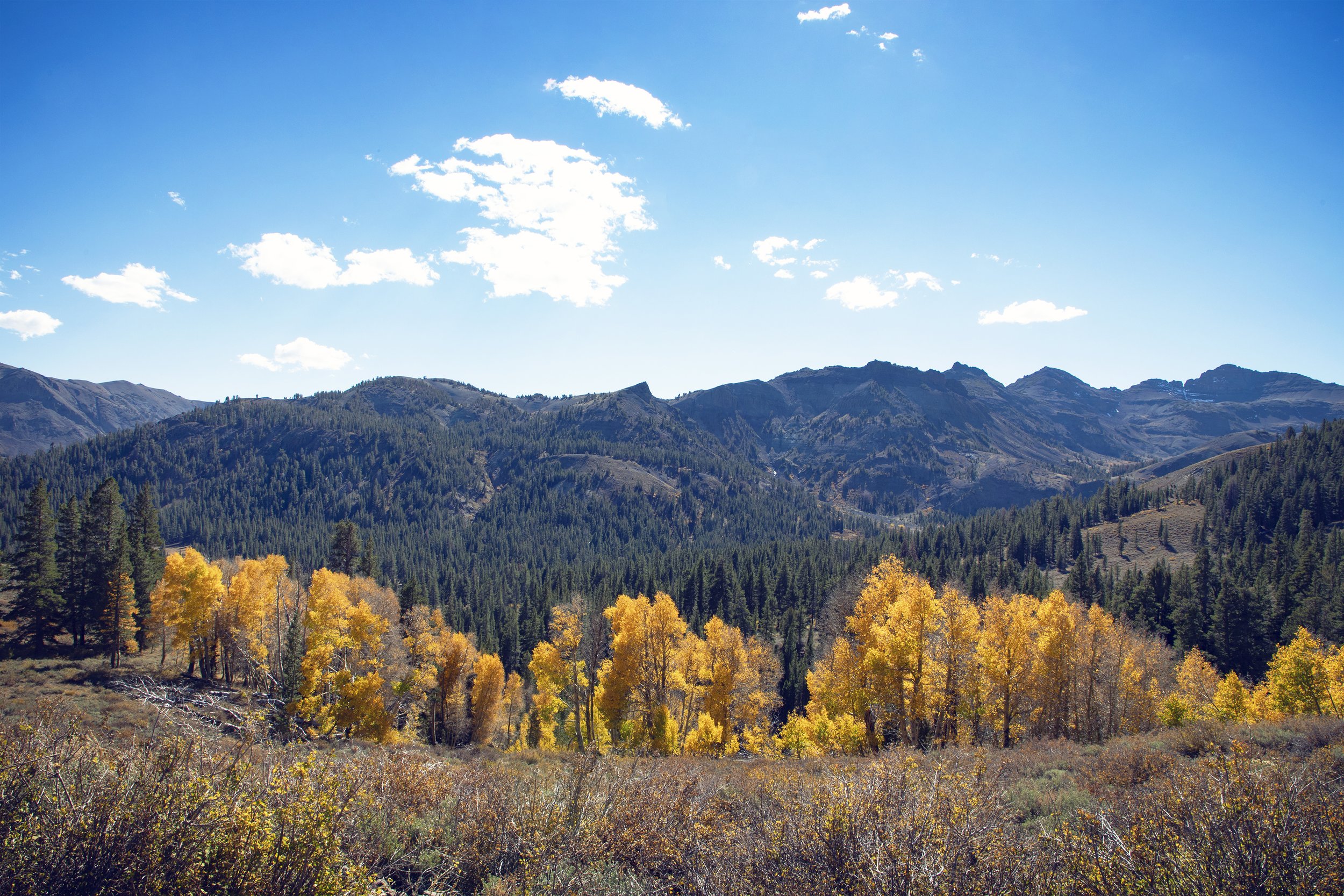
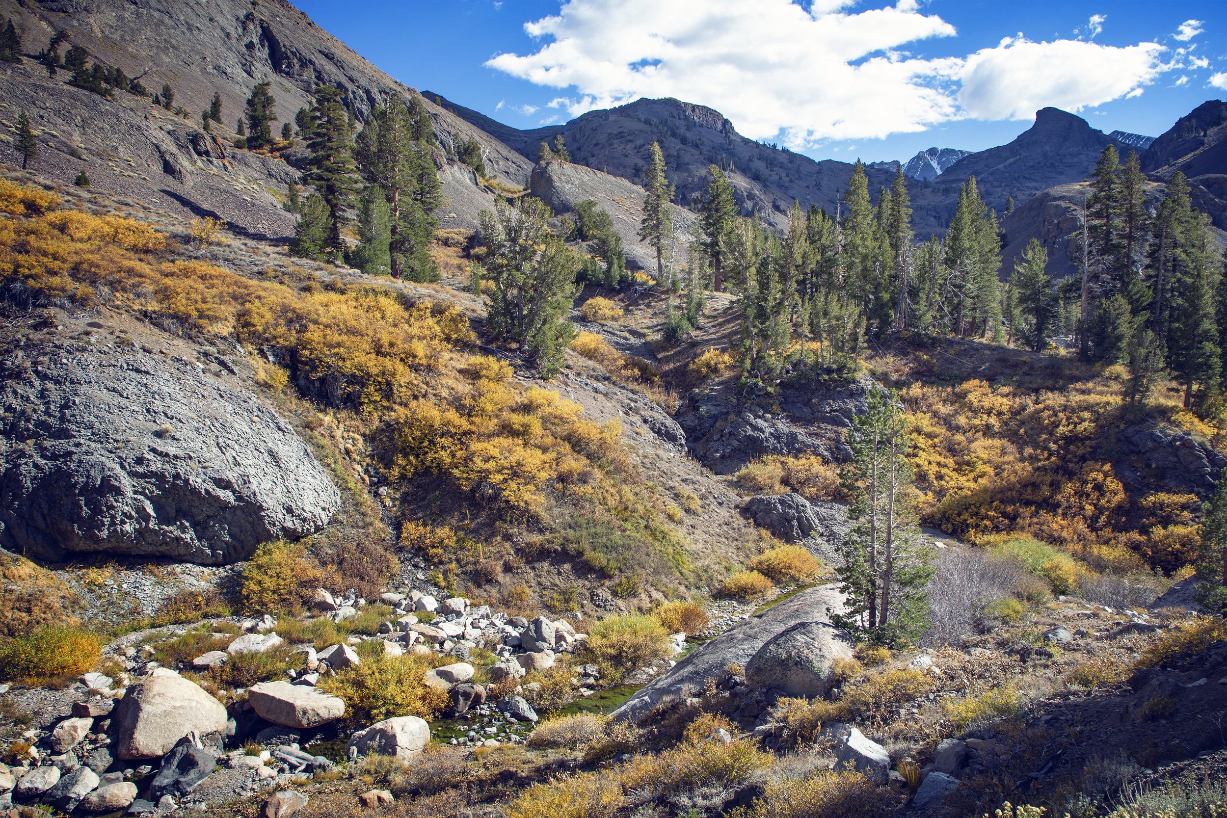
Fall colors near Leavitt Meadow along Sonora Pass Hwy-108
Eastern Sierra Fall Colors 2-4 Day Itinerary & Travel Guide
If you’re planning a Highway 395 road trip during the fall months, make sure to download my complete Eastern Sierra Fall Colors 2-4 Day Itinerary & Travel Guide, which includes an hour-by-hour schedule, Google & Apple map pin locations, the best stargazing spots, a dining guide, recommendations on where to stay, photography tips, and more! Download it today and make your fall foliage planning easy!

Fall colors along Sonora Pass Hwy-108
Location
Sonora Pass is the second-highest mountain pass with a road in California situated at over 9,600 feet (only 321 feet lower than Yosemite’s Tioga Pass to the south). Sonora Junction and the gateway through Sonora Pass is located just 20 miles past Bridgeport on Hwy-395. SR-108 traverses the pass and is extremely steep (exceeding 8% for much of the pass with up to 26% grades in some locations). Although it is narrow and winding in many areas, the drive is incredibly scenic, especially in the Fall when it showcases stunning Autumn leaf colors.

Fall colors in Walker River Canyon near Sonora Pass Junction
Walker River Canyon
For Fall leaf peepers, there’s a spot just north of the Sonora Pass Junction I always stop to view the foliage. The West Walker River hugs Highway 395 and provides beautiful Autumn scenery. The Walker River Canyon and Antelope Valley here are peppered with pine, willow, aspens, and cottonwood, creating a wonderful array of greens, yellows, and oranges in the Autumn...so before turning onto Hwy-108, this is a great spot to see the colors.

Sonora Pass Hwy-108 ascends above Leavitt Meadow with Fall colors
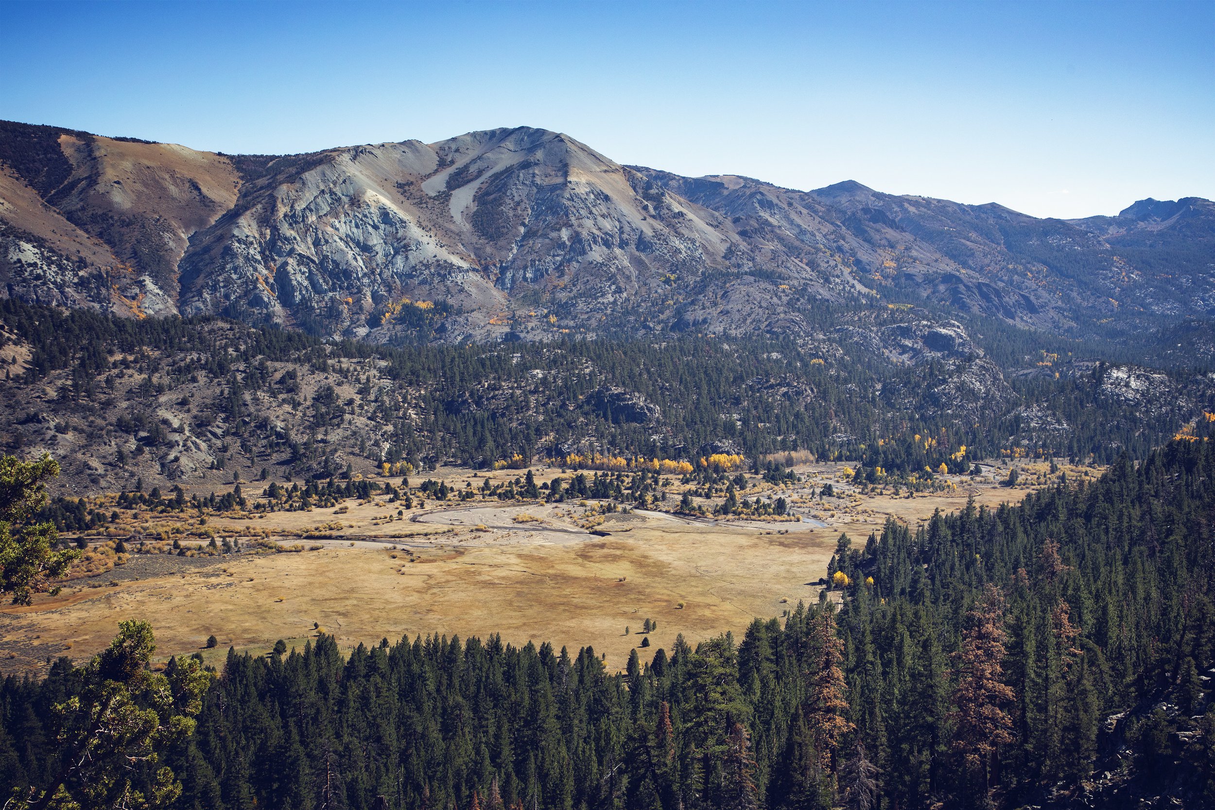
Leavitt Meadow seen from Leavitt Falls viewing platform
Leavitt Meadow
Nestled amidst Jeffrey Pines alongside the West Walker River, the 2 mile-long Leavitt Meadow is situated 7,100 feet above sea level and is a prime spot to see the Eastern Sierra Fall colors. The Leavitt Meadows Trailhead is the starting point for horse or foot trails, and climbers use this trail to approach Tower Peak, which offers both technical climbs and scrambles.

Leavitt Falls along Sonora Pass Hwy-108

Leavitt Falls along Sonora Pass Hwy-108
Leavitt Falls
Driving 1.3 miles west from the Leavitt Meadow Pack Station, you’ll find a sign and turnoff on your left for Leavitt Falls. A short trail leads to a platform overlook, and this viewpoint is especially unique...it’s not often you find a waterfall and fall colors side by side in California. The wooden viewing platform makes it easy to soak in panoramic views of the waterfall, as well as Leavitt Meadow down below. The waterfall drops over 250 feet in several steps, and while there’s no trail to the base of the falls, you get great views from the viewing platform. For closer-up views, you can scramble down a dirt path to an unofficial viewpoint atop granite boulders.

Old cabin along Sonora Pass Hwy-108

Old cabins near Leavitt Meadow along Sonora Pass Hwy-108
Old Abandoned Cabins
A number of old rundown stone & wooden structures can be found scattered along Hwy-108 near Leavitt Meadow. Some cabins here were once fishing or hunting cabins, but many were built by ranchers for the ranch hands who tended cattle on mountain ranges. Driving stock to the high country in the Summer was a common practice into the mid-20th century. Quite a few of these run down structures require a decent hike to reach, but a few stand just off the road.

U.S. Marine Corps Mountain Warfare Training Center with Fall colors
Mountain Warfare Training Center
The United State MWTC is located in Pickel Meadow along SR-108, 6,800 feet above sea level in Toiyabe National Forest. This isolated military base was established in 1951 and was specifically opened to deal with the Korean War. The training center exists to train units in complex compartmented terrain, and while the base is completely off limits, the hillside above the base is easily viewed from the road, and for a few weeks every Fall the trees put on a brilliant display of Autumn colors before the harsh Winter snow arrives.
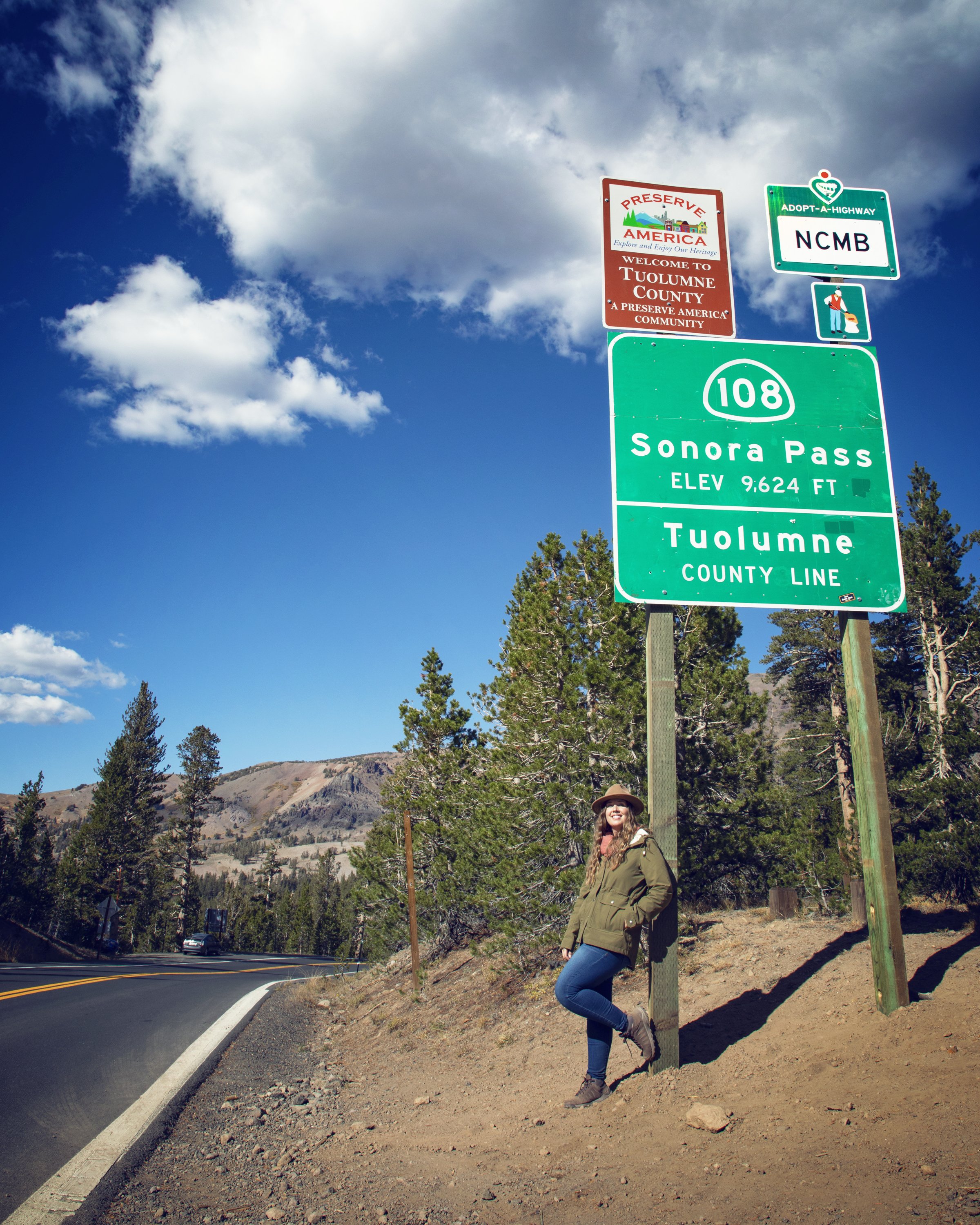
Sonora Pass summit along Hwy-108
Sonora Pass
The winding road is lined with Aspen, which are currently peaking with Fall colors leading to the official Sonora Pass point at an elevation of 9,624 ft at the Mono County/Tuolumne County line. Here at the high point is also where the Pacific Crest Trail crosses the road, and it’s a wonderful spot for day hikes as well. A small plaque here marks the Sonora Mono Toll Road, the oldest of the trans-sierra emigrant trails to California. The pass also marks the boundary between Toiyabe National Forest and the Stanislaus National Forest.
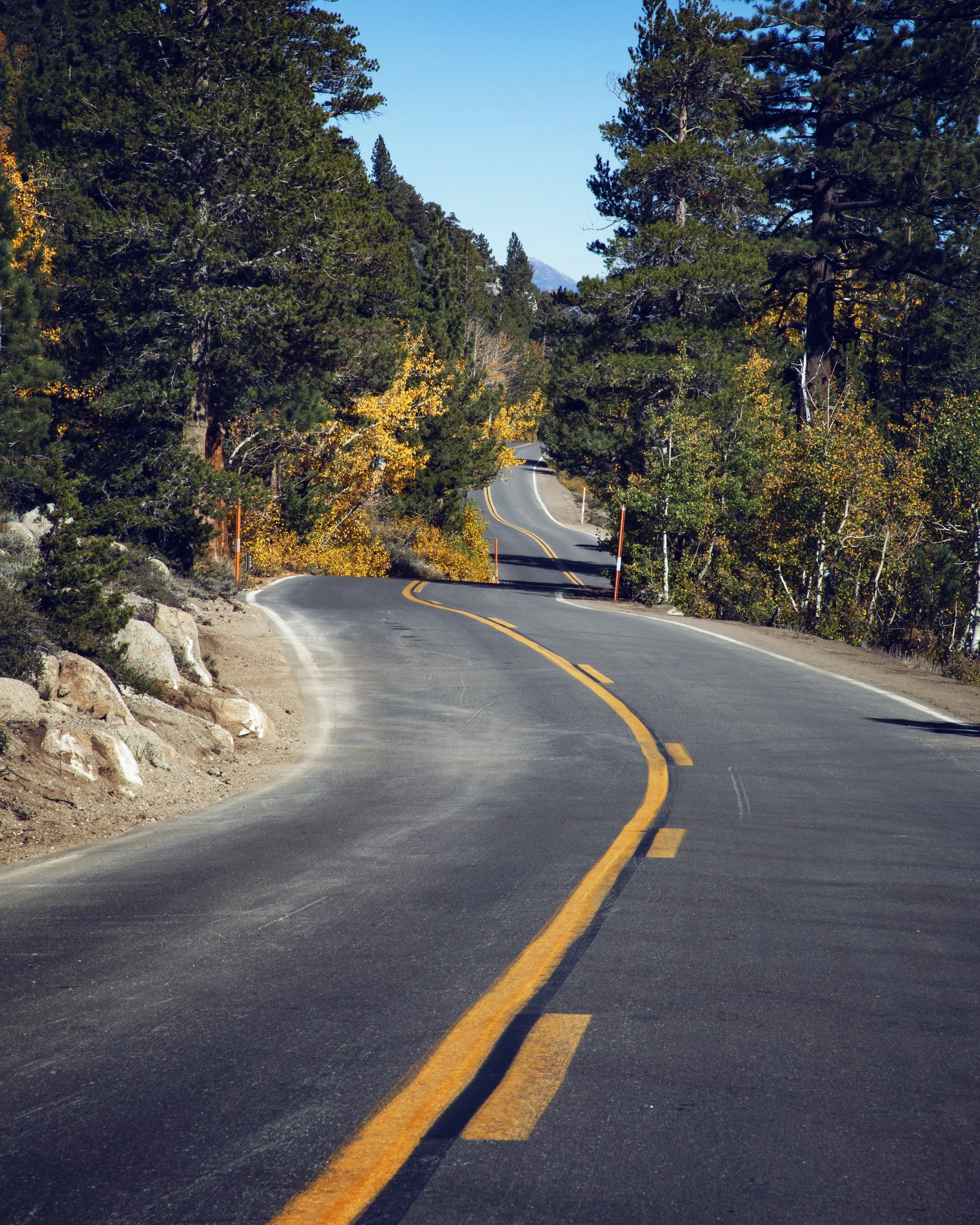
Fall colors east of Sonora Pass summit along the windy Hwy-108
Deadman Creek west of Sonora Pass summit
Winding Hwy 108
As you gain substantial elevation, the driving grows more windy with steep grades, but it also has some of the most stunning pull-outs for Fall foliage views. One of my favorite views is looking out towards Deadman Creek with the mountain peaks towering above in the distance.

Middle Fork Stanislaus River along Hwy-108
Stanislaus River
The Stanislaus River runs over 100 miles long, originating as three forks, and it’s known for its swift rapids and scenic canyons. The North Fork begins at Highland Creek...numerous lakes and parks are found along this steep northern fork. The middle fork is home to numerous scenic campgrounds and RV camps as the water flows through Stanislaus National Forest along Hwy-108. South Fork Stanislaus is the shortest of the forks and eventually the massive river ends up in the San Joaquin Valley, growing the California crops. Some of my favorites stops on the Hwy-108 drive are along the Middle Fork Stanislaus River watching the rapids tumble down the granite formations.

Columns of the Giants in Stanislaus National Forest
Columns of the Giants
Found just off Highway-108 in the Stanislaus National Forest, Columns of the Giants is a great stop when traveling across the Sonora Pass of the Sierra Nevada Mountains. A paved parking lot and trailhead are located just east of the small town of Dardanelle and right next to the Pigeon Flat Campground. From the parking area, there is an easy 0.25 mile paved trail that leads you out to the official Columns of the Giants viewing point. The out and back trail begins by crossing a picturesque wooden footbridge above the Middle Fork Stanislaus River and for details on this unique geological wonder see my full Columns of the Giants blog post.

Aspen trees with Fall colors line Hwy-108 west of Sonora Pass summit
Know Before You Go
• Please remember the Leave No Trace Principles on your adventures here.
• The Sonora Pass Highway-108 is steep, narrow, and curvy in many places. Long and/or large vehicles are not recommended along this road.
• This area is best enjoyed during Summer & Fall, as parts of SR-108 are closed annually during the Winter due to inclement weather along the summit.
• There is minimal or no cell service for much of this drive...always plan ahead and tell someone your travel details before heading out.
• This is black bear country. Bears and other wildlife can be present on trails at any time of the day or night. Feeding and approaching wildlife is dangerous and illegal. Make sure to properly store your food. Bear canisters are required for wilderness food storage for overnight hikers.
• The leaves in this area typically turn later in the season, so if you’ve missed the colors peaking in other regions of the Eastern Sierra, this is a great spot to check out.

Aspen trees with Fall colors line Hwy-108 west of Sonora Pass summit
In Summary
Thank you so much for joining me this week to explore the High Sierra Fall colors. For a virtual visit of Sonora Pass, see my Behind the Blog YouTube video located at the top of this post. Until next week, I hope you find adventure and encouragement wherever you go.

Aspen trees with Fall colors along Sonora Pass Hwy-108
If you enjoyed this post, you might also like…


About Me
I’m Dawn Marie, a travel and lifestyle blogger based out of Southern California. With in-depth articles, travel guides, and reviews on hotels & products, I seek to share my journeys to help you plan for your own. My adventures take me all over California, the western United States, and around the globe...and every Monday I post new content here, including a comprehensive blog post and YouTube video.
Search the Blog
Featured Posts


Etsy Shop

Discover the best astrophotography locations in California and learn how to capture stunning night sky photos. From Yosemite to Death Valley and Joshua Tree to Sequoia National Park, this beginner’s guide covers top gear, camera settings, top dark sky spots, and tips for photographing the Milky Way, stars, and constellations. Experience the awe of God’s masterpiece under the stars with me!