Exploring the Stops along Bajada Loop Drive - Saguaro National Park
Happy Monday fellow adventurers! This week we’re exploring the rich desert beauty found inside Saguaro National Park and today I’m sharing the ultimate guide to taking the scenic Bajada Loop Drive. Get ready to immerse yourself in the beauty of towering saguaro cacti, stunning desert landscapes, and a myriad of outdoor activities perfect for road trip families, outdoor enthusiasts, and national park adventurers alike. Join me below as we take a look at each stop along Bajada Loop Drive.

Signal Hill Petroglyphs along Bajada Loop Drive
Location
Located in southern Arizona on the fringes of Tucson, Saguaro National Park is a haven for nature photographers and outdoor adventurers. Divided into two districts, the East and West, the park boasts impressive displays of the iconic saguaro cactus, fascinating Native American petroglyphs, as well as diverse desert flora and fauna. Bajada Loop Drive visits some of the most accessible features found in the Saguaro West (aka Tucson Mountain District) section of the park. This is popular area of the park…so I recommend visiting early in the morning and on weekdays if at all possible.

Bajada Loop Drive in Saguaro West
Overview
Combining Hohokam Road and Golden Gate Road, Bajada Loop Drive offers scenic views passing through the western edge of Saguaro National Park. This 6 mile loop is an unpaved but well-maintained dirt road. I recommend taking the loop counter-clockwise, starting on the one-way Hohokam Road, which can be accessed 1.5 miles west of the Red Hills Visitor Center along the paved Kinney Road. This drive stops at many beautiful trailheads and picnic areas, and it ends where Golden Gate Road meets Sandario Road. This drive is perfect for families seeking an unforgettable road trip experience with breathtaking saguaro vista views.

Sus Picnic Area CCC structure along Bajada Loop Drive

Sus Picnic Area in Saguaro National Park
Stop 1: Sus Picnic Area
When driving counter clockwise along this loop, the first official stop along the journey is the Sus Picnic Area. This picnic area here is surrounded by a beautiful desert-scape of saguaros and unique rock formations, and it’s a great spot to enjoy an early morning coffee or an afternoon bbq with the family. There are several picnic tables, awnings for shade, as well as grills. The Civilian Conservation Corps (CCC) was responsible for building 8 different picnic areas in the region, consisting of beautifully crafted stone tables, benches, fire places, shelters, and “comfort stations” (aka restrooms)...so the amenities you see here are historic and composed of stone built by the CCC almost a century ago. The Bajada Wash Trailhead is located here, and this is an easy 1.7 mile point to point hike perfect to stretch your legs.

Valley View Overlook in Saguaro West

Valley View Overlook Trail along Bajada Loop Drive
Stop 2: Valley View Overlook Trail
The next stop on our journey is the Valley View Overlook Trail. This out and back family-friendly hike can be completed in under a mile out and back with just over 50 feet in elevation change. This trail crosses two washes and takes you through a diverse cactus landscape to a final overlook that showcases the seemingly endless saguaro cactus forest below, along with great views of the Avra Valley and Picacho Peak. The Bajada Wash Trail also connects with this hike, as does the Wild Dog Trail, which cuts across the Bajada Loop to the Signal Hill area.
For details on this wonderful hike see, my full blog post on Valley View Overlook.

Ez-Kim-In-Zin Picnic Area built by the CCC

Ez-Kim-In-Zin CCC picnic structure in Saguaro West

Sendero Esperanza Trailhead in Saguaro National Park
Stop 3: Ez-Kim-In-Zin Picnic Area
For our next stop, we’ll be taking a slight detour off the official Bajada Loop Drive. As we continue on the dirt road from the Valley View Overlook Trailhead, the one-way section of this loop comes to an end at Golden Gate Road. Taking a left continues the official loop, but a quick 1 mile detour to the right leads to another picnic area constructed by the CCC called Ez-Kim-In-Zin. Ez-Kim-In-Zin offers great views of Wasson and Amole Peaks, as well as a wonderful sheltered picnic spot, which might be one of my favorite CCC structures in the area. If you’re looking for a more moderate hike, the trailhead for the Sendero Esperanza Trail is near here, which is about 6 miles out and back with over 600 feet in elevation change...and it connects you to other trails in the area, such as the popular Gould Mine and Kings Canyon Trails.

Signal Hill Petroglyphs viewing area in Saguaro National Park
Signal Hill petroglyph along Bajada Loop Drive
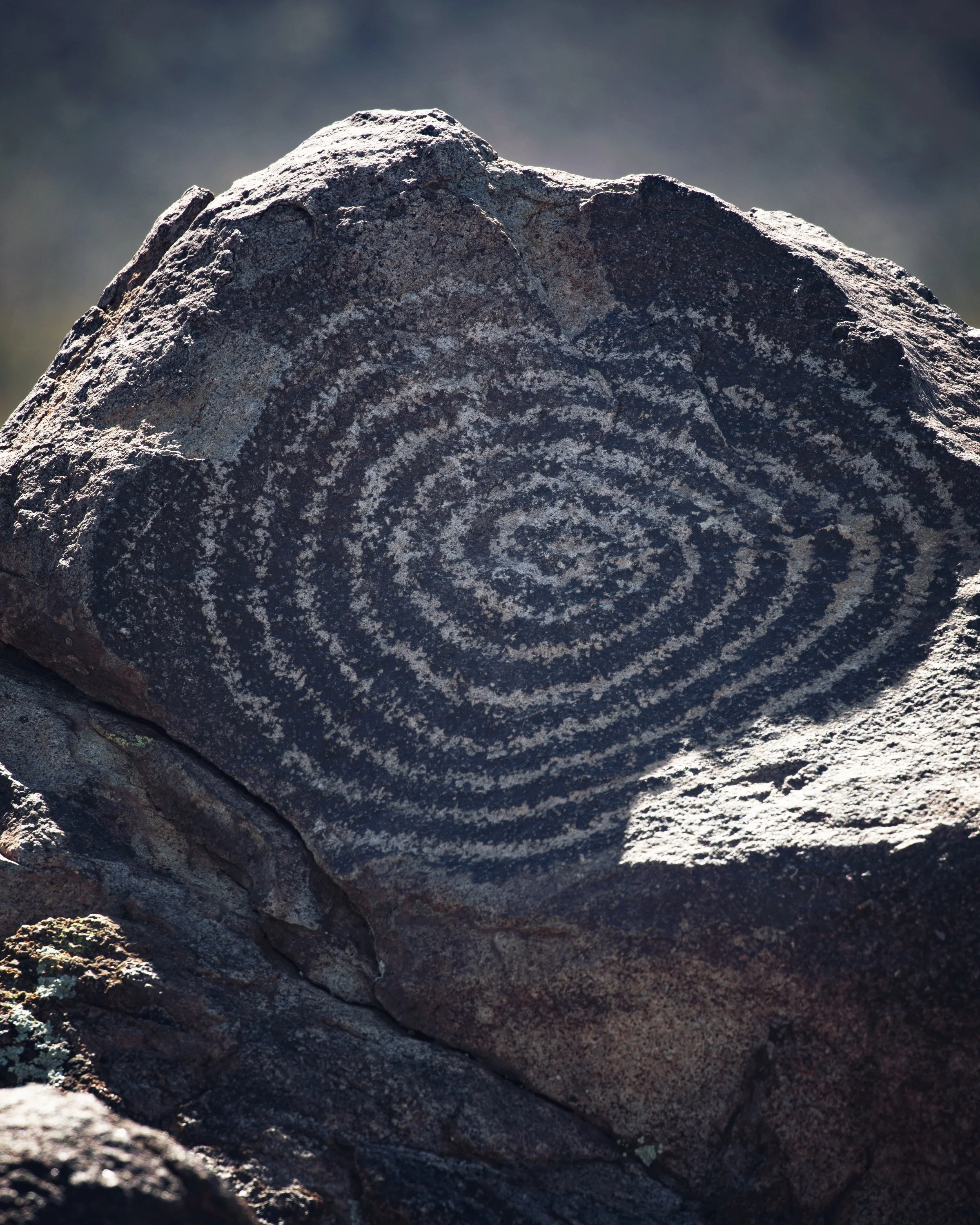
Stop 4: Signal Hill Petroglyphs
Heading back onto the official Bajada Loop, the last stop on this journey is a historic and popular feature in the park, the Signal Hill Picnic Area and Petroglyphs. The Sonoran Desert here was home to the local Hohokam people as far back as 450AD, and the Signal Hill Petroglyphs site encompasses a unique rocky hill approximately 200 feet in diameter at its base and 40 feet high. Over 200 Native American petroglyphs cover this area, many of which are easily viewed from the trail, which is an easy quarter mile hike up a 50 foot stone carved staircase.
2024 Closure Alert: The Signal Hill Picnic Area, parking lot, and access road is undergoing a restoration project in the first half of 2024. Check out the “Know Before You Go” section below for more info.
For more details on this incredible spot see my full blog post on Signal Hill Petroglyphs.

Signal Hill Petroglyphs in Saguaro West
Know Before You Go
• Always practice the Leave No Trace Principles to help preserve the beauty of this natural treasure for future generations. Remember the 10 essentials and pack plenty of water, sunscreen, snacks for even a short visit.
• 2024 Signal Hill Closure Alert: The Signal Hill Picnic Area, parking lot, and access road is undergoing a restoration project, which may last until May. Until the project is complete, there will be periodic closures. According to the NPS, “During closure periods, there is no public access to the Signal Hill Picnic Area. The road to Signal Hill from the Bajada Loop Drive will remain closed to traffic of all kinds. Please refrain from parking in the road. Do not park in front of barricades; contractors need access during construction.” During closures, you can still access the petroglyphs viewing area via the Cactus Wren Trail or the Manville Trail. For more information, visit the official NPS website or call the Red Hills Visitor Center at (520) 733-5158.
• High clearance or four-wheel drive is not needed to drive the loop, but trailers longer than 35 feet or any vehicle wider than 8 feet is not permitted.
• Before embarking on your Bajada Loop Drive adventure, be sure to check Saguaro National Park’s website for the latest information on road conditions, weather forecasts, and trail closures.
• Bicycling is permitted along the Bajada Loop Drive, however bicycling is not permitted on any trails, except the 0.5 mile Belmont Multi-use Trail and the 2.5 mile Golden Gate Multi-use Trail.
• Saguaro National Park is home to a diverse array of wildlife, including javelinas, coyotes, desert bighorn sheep, and rattlesnakes. Both rabies and tick borne spotted fever is present inside the park, so avoid contact with wildlife and report any odd animal behavior.
Top 10 Things to Do in Southern Arizona
Tombstone
Coronado National Memorial
Picacho Peak State Park
Fort Bowie National Historic Site
Organ Pipe Cactus National Monument
Pima Air & Space Museum
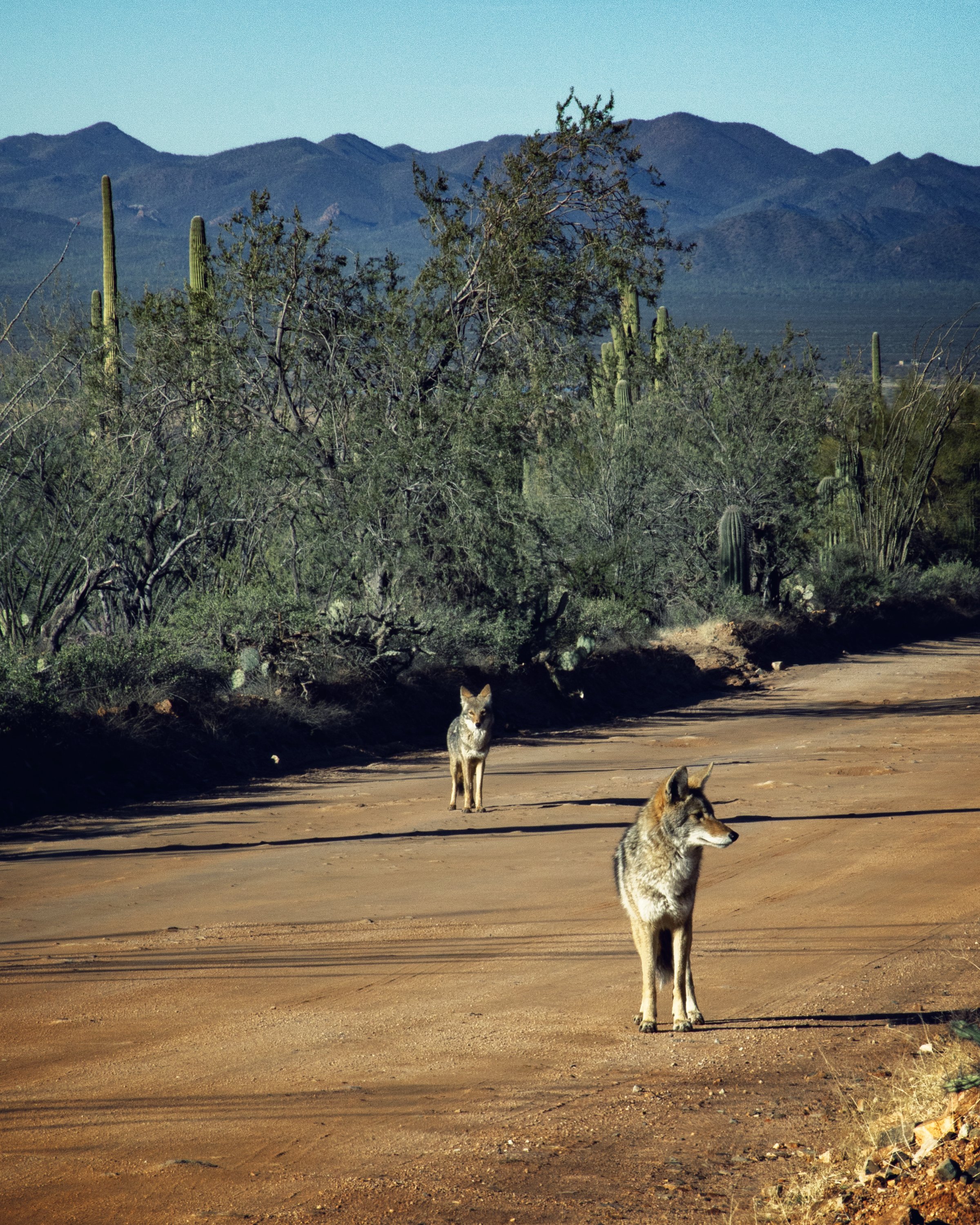
Coyotes along Bajada Loop Drive in Saguaro National Park
In Summary
Thanks so much for joining me this week inside Saguaro National Park. For a virtual visit of Bajada Loop Drive, make sure to watch my Behind the Blog video located at the top of this post, or watch it on YouTube here. Until next week, I hope you find adventure and encouragement wherever you go.

Giant saguaro along Valley View Overlook Trail
If you enjoyed this post, you might also like…


About Me
I’m Dawn Marie, a travel and lifestyle blogger based out of Southern California. With in-depth articles, travel guides, and reviews on hotels & products, I seek to share my journeys to help you plan for your own. My adventures take me all over California, the western United States, and around the globe...and every Monday I post new content here, including a comprehensive blog post and YouTube video.
Search the Blog
Featured Posts


Etsy Shop

Plan the perfect day trip to Saguaro National Park! Check out this 1 day itinerary, which includes 10 top spots to visit in Saguaro West & East, including hiking details and viewpoints of Saguaro's best areas, Bajada Loop Drive, Cactus Forest Drive, and Signal Hill. If you're planning a multi-day road trip, download my complete 2 Day Itinerary & Travel Guide, which includes hotel & dining info.