First-Timer's Guide to Chiricahua National Monument
This week we’re partnering with Discover Bisbee and taking a road trip to an otherworldly spot in Southern Arizona lovingly referred to as the “Wonderand of Rocks.” Join me as we explore some of my favorite things to do at Chiricahua National Monument.

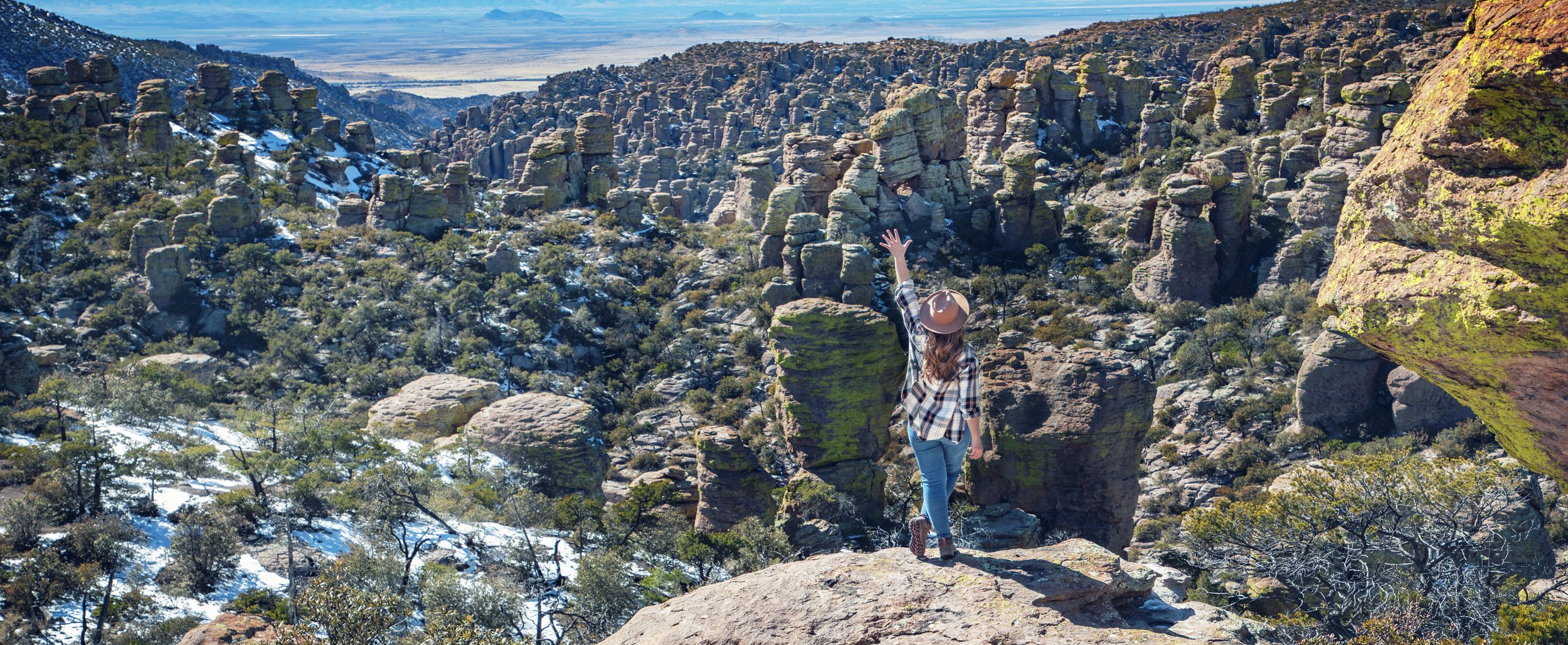
Chiricahua National Monument in Arizona
Location
Situated in the Chiricahua Mountains in the southeast corner of Arizona, this incredible park makes for a perfect day trip from Bisbee (about a 1.5 hour drive) or from Tucson (about 2 hours away). Although a relatively small park at roughly 18 square miles, Chiricahua National Monument has an abundance of hiking trails and history to explore, so your visit can certainly be made into a 2-3 day adventure. Ranging from 5124 to 7310 feet in elevation, Chiricahua National Monument is considered one of Arizona’s “sky islands”, experiencing much cooler weather than other parts of the state. Although rare in recent years to due drought conditions, snowfall in winter months is a common occurrence (and a treat!), as you’ll see in the photos and videos today.

Bonita Canyon Drive in Chiricahua National Monument
Geology
Eons ago, the nearby Turkey Creek Caldera exploded with a massive volcanic eruption, spewing ash and molten debris across this region, forming a thick layer of rock called rhyolite tuff. Erosion and fissuring then commenced over the centuries, resulting in the bizarre landscape we see today. These unusual rock formations, called hoodoos, consist of pinnacles, balancing rocks, and columns.

Echo Canyon Trail in Chiricahua National Monument
History
With the truly unique and beautiful terrain, it’s no surprise that this region has attracted people groups for centuries. The history here is important and rich, and one small section on this blog post certainly doesn’t do it justice. Below is a quick overview, but for a more in-depth look at this region’s complicated past, make sure to check out the official NPS page here.
Somewhere between 1400 and 1500 AD, the Chiricahua Apache settled here after migrating from the North American northwest due to warring tribes in that region. These bands of Apache thrived in this area until conflicts arrose with Spanish explorers, the newly independent nation of Mexico, and then with the United States Army during the Apache Wars in the mid-to-late 1800s.
As the Apache Wars came to end in the late 1800s as Geronimo, Chief Naiche, and Chief Mangus were captured and relocated to Florida, white settlers began to arrive at the foothills of the Chiricahua Mountains in Bonita Canyon. Some of these early pioneers included the Prues, the Ericksons, the Staffords, and the Riggs family, many of which played integral roles in the establishment of the Chiricahua National Monument in 1924.
The Civilian Conservation Corps, which was formed after the Great Depression to provide young men employment by improving federally owned lands, spent several years here in the 1930s. They built numerous structures and constructing miles of trails, some of which we’ll be exploring on our journey today. You can see more of the CCC’s work in my Sequoia National Park posts on Moro Rock, Hospital Rock, and Tunnel Rock.

Organ Pipe Rock at Ciricahua National Monument

Sea Captain Rock at Chiricahua National Monument
Top Things to Do in Chiricahua National Monument
There are plenty of wonderful activities in the park, from historical landmarks and scenic overlooks to abundant wildlife and intense hiking trails. This park has something unique to offer to visitors of all kinds. Continue reading for some of my favorites...
Bonita Canyon Drive
This scenic 8-mile paved road takes you from the lush foothills along Bonita Creek, through the towering hoodoos, and up to the overlook peak of Massai Point. There are multiple pull-offs along the drive for both trailhead access and for scenic views. The Organ Pipe Rock and the Sea Captain Rock are two of the featured formations along the journey. Can you spot the profile of a “sea captain” in the rocks pictured above?

Grottoes along Echo Canyon Trail in Chiricahua

Echo Canyon Grottoes in Chiricahua National Monument
Echo Canyon Trail & Grottoes
The Echo Canyon Trail is a perfect introductory hike for first time park visitors. The full 3 mile loop combines the Echo Canyon, Hailstone, and Ed Riggs Trails, and takes you through a diverse landscape of woodlands and spectacular rock formations. However, if you’re short on time, you can just take the easy 1 mile out and back section of the trail to the Echo Canyon Grottoes, which still provides great up-close views of the wilderness area here and the opportunity to walk through this otherworldly terrain.

Massai Point Overlook at Chiricahua National Monument
Massai Point Overlook & Nature Trail
Named after a Chiricahua Apache who served as a scout for the 3rd Calvary, Massai Point provides some of the most incredible and accessible panoramic views in the park. From the exhibit hut just a short stroll from the parking area, you have 360º views of Rhyolite Canyon, Cochise Head, and the surrounding peaks and valleys. The Massai Point Nature Trail also leads you around the hillside to a spectacular viewing platform built by the CCC nearly a century ago...and all along the trail, multiple informative panels tell of the rich geological and human history of this park.

Faraway Ranch at Chiricahua National Monument

Erickson Cemetary near the Chiricahua entrance
Faraway Ranch
Soon after the local Apache people were removed from there land here, the Ericksons, who were Swedish immigrants, created a homestead here in the Chiricahua Mountains. By the 1920s, this homestead became a guest ranch where visitors were lucky enough to come and enjoy this beautiful area. The ranch later went on to became a historic district within the Chiricahua National Monument. The homestead is open for visitors to explore year round, and the NPS even provides guided tours inside the main house, which is currently closed due to extensive renovations. According to a ranger, these tours will hopefully resume in 2024. Check the NPS official website for up-to-date information.
Located down the road a bit near the park entrance, make sure to also visit the Erickson Cemetery, where you’ll find the final resting spots for many of these early pioneers.

Bonita Creek along Bonita Creek Trail in Chiricahua
Bonita Creek Trail
This gentle 1.3 mile out and back trail takes you along Bonita Creek in the foothills of this national monument. This hike combines perfectly with a visit to Faraway Ranch since one of the trailheads shares the same parking lot. Several picnic areas and restrooms are available at both ends of trail, and this area provides one of the best opportunities to see wildlife in the park.

Massai Point Nature Trail in Chiricahua National Monument
Other Hiking Trails
There are several other hiking options throughout the park as well. Natural Bridge Trail is a 5 mile out and back hike to a wonderful feature (you guessed it), a natural bridge made out of rhyolite rock.
Although not very long, the 2 mile out and back trail to the top of Sugarloaf Mountain is a bit steep with 470 ft in elevation. This trail takes you to a fire lookout constructed by the CCC, which marks the highest point in the park, 7310 ft above sea level.
Lower Rhyolite Canyon Trail provides an opportunity to hike through these pinnacles and balancing rocks without having to drive up Bonita Canyon Drive. Starting at the Visitor Center, take the trail about 1.5 miles before turning back the way you came.
A more strenuous option would be the hike to Inspiration Point. Heading out from Massai Point, you combine the Ed Riggs and Mushroom Rock Trails to the Inspiration Point Trail for a total of 5.5 miles round trip with over 1000 ft in elevation gain.

Deer near Faraway Ranch in Chiricahua
Look for Wildlife
The area surrounding Faraway Ranch in Bonita Canyon is the ideal spot to look for wildlife in Chiricahua National Monument, especially at sunrise or sunset. During my recent visit, deer were abundant in this area in the morning and evening. I also got to enjoy seeing large groups of coati, javelina, and wild turkey. The name “Chiricahua” is actually an Opata word for the wild turkeys that once thrived in these mountains. Unfortunately, they were hunted to local extinction in this region by the early 1900s...however, in the 1990s wild turkeys were reintroduced to the Chiricahua Mountains and surrounding region, and their numbers have quickly grown ever since. With almost 200 species of birds recorded in the park, birders are also sure to enjoy a trip to Chiricahua National Monument.

Chiricahua National Monument Visitor Center
Chiricahua National Monument Visitor Center
Last, but certainly not least, make sure to stop by the Visitor Center on your trip. Inside you’ll find plenty of informative displays on the park’s wildlife and geology, as well as the human history here. Make sure to ask the park rangers and staff here any questions you might have...they are extremely kind and eager to share their vast knowledge of the region.

Faraway Ranch at Chiricahua National Monument
Know Before You Go
• Please remember to take only pictures and leave only footprints. Pack out everything you pack in and stay on the designated paths. If you’re not familiar with the Leave No Trace Principles, consider familiarizing yourself with them before your trip. Please help leave this special place better than you found it so its natural beauty can be enjoyed for years to come.
• Roads and trails can close occasionally in winter months due to snowy and icy conditions, so make sure check current conditions on the official NPS website here.
• Black bears are present in the Chiricahua Mountains, so never leave food out or unattended, especially in your vehicle.
• Admission to the park is free, and gates are open 24/7.
• This is a great location for stargazing and astrophotography. In fact, in 2021, the National Park Service and the International Dark Sky Association announced that Chiricahua National Monument would be named the 104th International Dark Sky Park.
Top 10 Things to Do in Southern Arizona
Lowell
Chiricahua National Monument
Tombstone
Saguaro National Park
Coronado National Memorial
Picacho Peak State Park
Fort Bowie National Historic Site
Organ Pipe Cactus National Monument
Pima Air & Space Museum

Chiricahua National Monument in snow
In Summary & Post Sponsor
I’d like to give a huge thank you to the sponsor of this post, Discover Bisbee. Make sure to visit the official Discover Bisbee website and Instagram account for information on what to do in & around this beautiful and historic mining town.
Thanks so much for joining me this week in Chiricahua National Monument. For a virtual visit of this park, make sure to watch my Behind the Blog video at the top of this post, or watch it on YouTube here. Until next week, I hope you find adventure and encouragement where you go!

View along Echo Canyon Trail in Chiricahua National Monument
If you enjoyed this post, you might also like…


About Me
I’m Dawn Marie, a travel and lifestyle blogger based out of Southern California. With in-depth articles, travel guides, and reviews on hotels & products, I seek to share my journeys to help you plan for your own. My adventures take me all over California, the western United States, and around the globe...and every Monday I post new content here, including a comprehensive blog post and YouTube video.
Search the Blog
Featured Posts


Etsy Shop

Join me for the perfect day in Tombstone, Arizona. This top southern AZ spot is family friendly and a must see on any road trip to Tucson, Saguaro National Park, and Bisbee. A true Wild West boomtown, walk down the boardwalks of Allen Street, ride a stagecoach tour, explore a mine, walk through the Bird Cage Theater, and watch a reenactment of the most famous gunfight in the US at the OK Corral.