Stevenson Creek Falls Trail - Epic Waterfall Hike Near Fresno, CA
Hi friends! Tucked away in the heart of the Sierra National Forest, Stevenson Creek Falls offers an exhilarating adventure for hikers seeking breathtaking views, rich history, and a touch of solitude. This moderate hike leads you to one of Fresno County's tallest waterfalls, cascading approximately 1,200 feet down into the San Joaquin River Canyon. Whether you're a seasoned hiker or a nature enthusiast, this trail promises an unforgettable experience. Join me below as we head up into the Sierra Nevada Mountains for an epic waterfall hike.
FAST FACTS
• Distance: 7 miles RT
• Elevation Change: 700 ft
• Difficulty: Moderate

Stevenson Creek Falls in Sierra National Forest
Location
Located about 60 miles northeast of Fresno in the Sierra National Forest, the trail to Stevenson Creek Falls takes you along the historic Million Dollar Road, which also acts as a service road for the hydro-electric plant still in operation. The drive to the trailhead takes you through picturesque landscapes near the charming communities of Auberry and Shaver Lake, and as you ascend into the Sierra Nevada along the paved Jose Basin Road and Italian Bar Road, prepare for a winding narrow drive (one-lane at times) with stunning vistas that set the tone for the adventure ahead. You’ll pass multiple spots where the 2020 Creek Fire left its mark – however the hillsides are recovering quite nicely. During late Spring and early Summer, you’ll be treated with blankets of gold and purple wildflowers on both sides. Once at the trailhead, you’ll find a gate with a “Road Closed” sign, marking the beginning of the Million Dollar Road and several parking spots along the road just a stone’s throw away from the gate.
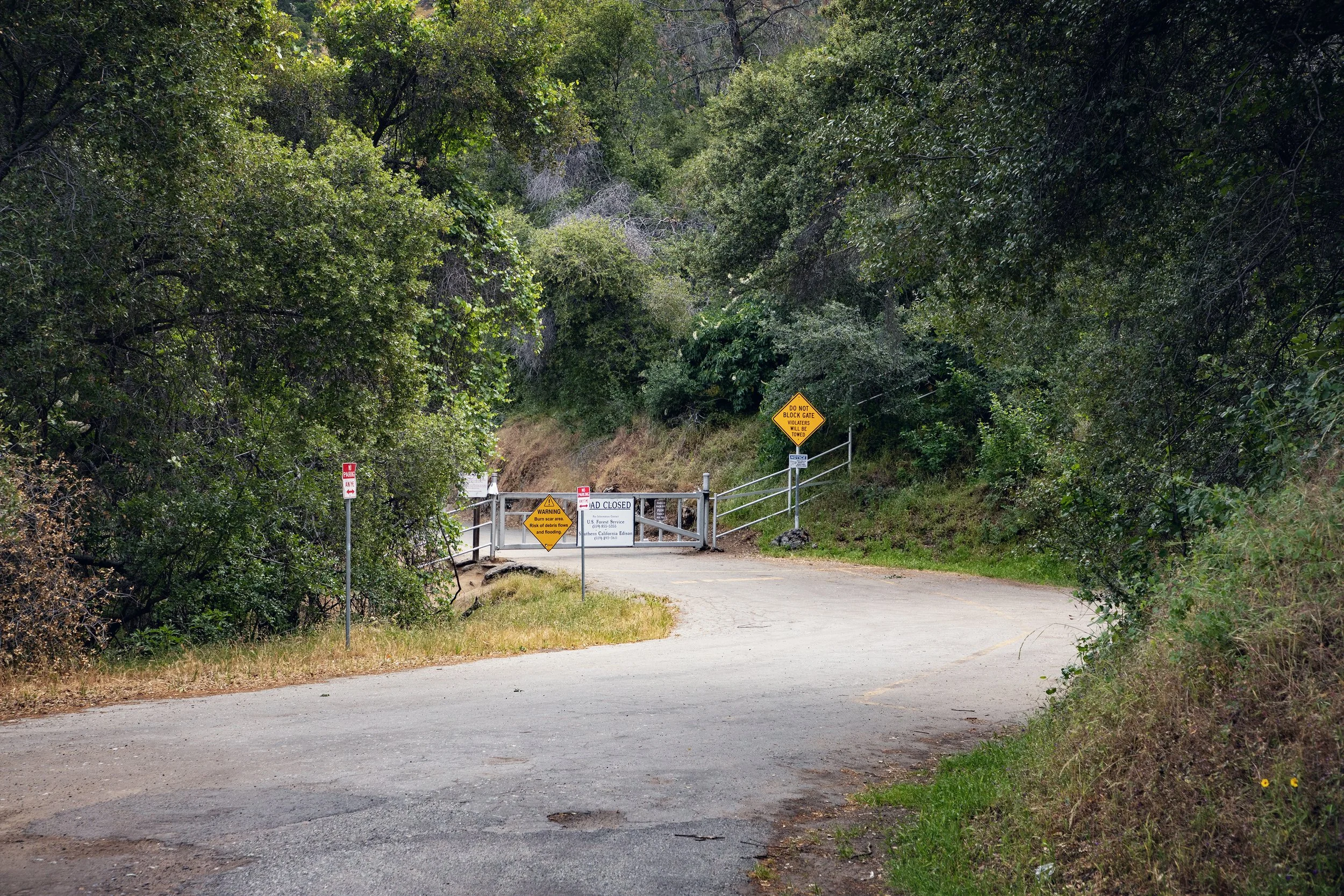
Stevenson Falls Trailhead & Million Dollar Road

Parking along Italian Bar Road near Stevenson Falls Trailhead

Southern California Edison hydroelectric plant along San Joaquin River
History
Long before modern hikers set out on waterfall adventures here, the Sierra National Forest was home to Indigenous tribes, such as the Western Mono, Northern Paiute, and the Yokuts. These communities thrived in the region, utilizing its resources and maintaining a deep connection to the land. The area around the San Joaquin River was rich in biodiversity, providing sustenance and cultural significance to these tribes.
In the early 20th century, the area became integral to Southern California Edison's Big Creek Hydroelectric Project. The construction of powerhouses and dams, including those near Stevenson Creek, transformed the landscape, channeling water to generate electricity for the growing needs of California. This ambitious project, often referred to as "The Hardest Working Water in the World," utilized a complex system of dams, tunnels, and powerhouses to harness the energy of the Sierra's waterways. The remnants of this era, including sealed tunnels and infrastructure, still dot the landscape, offering hikers a glimpse into the past.

Crossing the first grated iron bridge over Jose Creek

Tunnel “adit” halfway along Stevenson Falls Trail

Million Dollar Road above San Joaquin Rover
The Hike
The trail follows the historic Million Dollar Road, a fully paved one-lane service road for Southern California Edison vehicles. It’s said that each mile of construction cost a million dollars, hence the name! Within the first quarter mile, you’ll come across the grated iron bridge that crosses a beautiful cascading section of Jose Creek (also marked as Stevenson Creek on Apple Maps). This is a great spot to stop and explore before the trail’s elevation gain starts to kick in.
The path offers little shade, so starting early and bringing plenty of water is essential. Along the way, you'll encounter a sealed tunnel about halfway to the waterfall. Known as "adits," these tunnels are remnants of the area's hydroelectric history, which were once used to drain excess water. These features are not only fascinating to explore, but they offer the only reprieve from the blazing sun on hot days. The trail also offers panoramic clifftop views of the San Joaquin River Gorge, with opportunities to spot local wildlife and seasonal wildflowers. The elevation gain is fairly gradual most of the way with only a few dips, so take your time, hydrate often, and stop to enjoy the incredible views as much as you need. As you approach the falls, you’ll begin a slight descent as the sound of cascading water grows louder, building anticipation for the grand reveal.

Stevenson Creek Falls seen from bridge

Stevenson Creek Falls in Sierra National Forest
Stevenson Creek Falls
Stevenson Creek Falls is a majestic sight, cascading down several granite tiers about 1,200 feet into the San Joaquin River below. During the spring after a heavy winter, when snow melt feeds the creek, it can rage with tremendous force. The waterfall's flow is, however, regulated by Southern California Edison, which monitors the amount of water released from Shaver Lake to accommodate the power needs throughout the year. When it’s roaring, it is not only remarkable, it can be quite dangerous. A grated iron bridge passes over the falls, providing an excellent vantage point, but exercise caution during high flow periods, as the water can completely cover the bridge. In drier months, the falls may be reduced to a trickle, but the surrounding scenery remains captivating.
If it’s safe to cross, the best vantage points, in my opinion, are found just past the bridge. There’s a large viewpoint with large boulders to sit on, perfect for a mid-hike picnic with a view. Here, you’ll also find another tunnel, so take advantage of the opportunity for shade on sunny days. Further up the road provides even more impressive views, so make sure to explore past the bridge (only if it’s safe to cross!) before your return hike. Some road continues on, so hikers can continue on for an extended adventure, but most head back towards the trailhead once experiencing the waterfall.

Stevenson Creek Falls bridge

Stevenson Creek Falls cascading down into San Joaquin River Gorge

Tunnel “adit” just past Stevenson Creek Falls
Know Before You Go
• There are no restrooms or trash cans at the trailhead or anywhere along the trail, so plan ahead and pack out everything you pack in, honoring the Leave No Trace Principles.
• Wildlife is abundant in the Sierra National Forest. Never approach or attempt to feed wild animals, and never leave food unattended, especially in your vehicle, as this is black bear territory. There are no bear boxes at the trailhead, so plan accordingly.
• Cell service is unreliable along this drive and hike, as well as in many parts of Sierra National Forest, so bring a reliable GPS device with pre-downloaded maps. I love using Gaia GPS for iPhone and Android devices.
• Be prepared for sudden and sometimes hazardous changes in weather and trail conditions, especially during the Spring season...rock falls are common around waterfalls and the granite can become very slippery.
• Check weather reports, as well as road and trail conditions prior to setting out on your adventure.
• I can’t reinforce this enough – please use caution when crossing the bridge over Stevenson Creek Falls. If the flow is pouring over the bridge, enjoy the view from the trail and then turn back towards the trailhead without crossing.
• The whole path is paved, with the exception of the tunnel excursions, so plan footwear accordingly. Here are my favorite hiking boots & shoes.
• Bring more water than you think you need, as well as plenty of sun protection. Other than the two tunnels along the hike, there is no shade, and Fresno summers can be brutally hot.
• As mentioned previously, this road is still used frequently by Southern California Edison workers, so listen for approaching work vehicles and be cautious around blind curves.
• Bicycles and dogs on leash are permitted along the trail. However, both bridges are grated iron, so pets will need to be carried across.
• If you’re heading up to Yosemite National Park during your road trip, make sure to check the official NPS website for the most up-to-date road conditions, as well as reservation requirements. Peak-hour reservations will be required for the 2025 Summer season. For all the key dates and details, check out my full Yosemite 2025 Summer Reservation System blog post.
Top 10 Things to Do in Sierra National Forest
Sierra Vista Scenic Byway
Stevenson Creek Falls
Shaver Lake
Sierra Trails Horseback Riding
Huntington Lake
Downloadable Itineraries & Travel Guides


Enjoying Stevenson Creek Falls from viewpoint

Spring wildflowers along Stevenson Falls Trail
In Summary
Thanks so much for joining me this week inside Sierra National Forest. For a virtual visit of the hike to Stevenson Creek Falls, make sure to watch my Behind the Blog video located at the top of this post, or watch it on YouTube here. Until next week, I hope you find adventure and encouragement wherever you go.

Jose Creek cascades along Million Dollar Road
If you enjoyed this post, you might also like…


About Me
I’m Dawn Marie, a travel and lifestyle blogger based out of Southern California. With in-depth articles, travel guides, and reviews on hotels & products, I seek to share my journeys to help you plan for your own. My adventures take me all over California, the western United States, and around the globe...and every Monday I post new content here, including a comprehensive blog post and YouTube video.
Search the Blog
Featured Posts


Etsy Shop
